Electric vehicles are dependent upon batteries both for power and for design. That’s why General Motors’ recent announcement was a double break-through. A $20 billion investment in electric cars comes from a new kind of battery. Traditional EV batteries are a certain shape, determining the contours of a car. But GM’s new batteries can be stacked sideways, or even around curves, because the powerhouses are “soft, flat pouches.” (Valdes-Dapena, 2020). Tesla, by contrast, uses a hard cylinder. GM’s Ultium power cells may lead to curvy designs. Another advantage: Ultium uses far less cobalt that traditional EV batteries, significant because cobalt is becoming increasingly scarce. Finally, Ultium hits the desired metric: below $100 per kilowatt hour, the price point where electric cards are competitive with gasoline engines. According to estimates, electric vehicle sales in the USA will grow to 3 million units by 2030. Next-gen batteries enable driving ranges of 400 (and soon 600) miles. Longer range electric power means more highway trips, perhaps causing a redesign of the U.S. Federal Highway System, the Canada/USA Alaska Highway or the Pan-American Highway for a regional vision that could include a sportsway, maglev or hyper loop, in addition to vehicular paths. General Motors is partnering with LG Chem. With flexible batteries, look for different shapes to come.
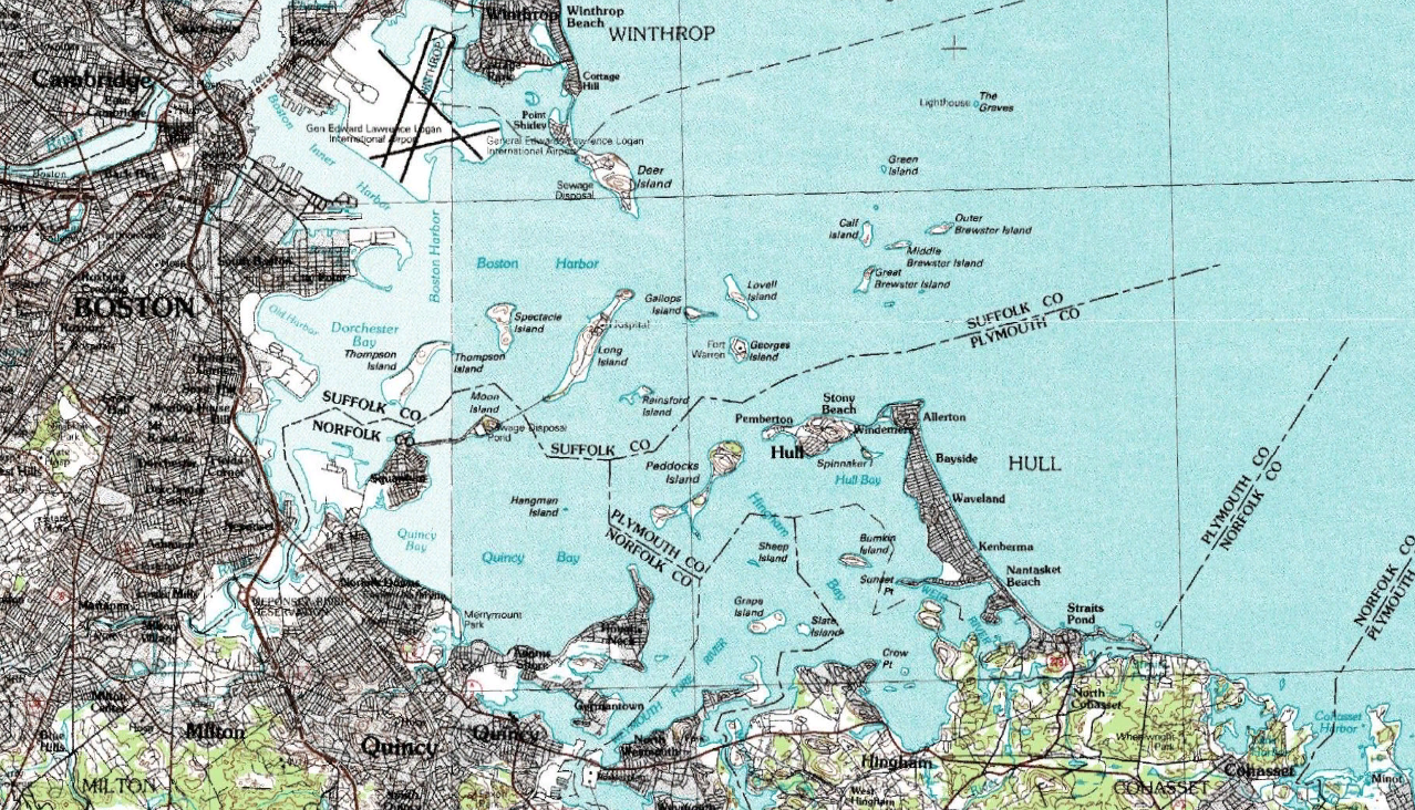
Boston, a port city, is threatened by rising seas. Map of Boston Harbor, wikimedia commons.
Coastal communities around the world are preparing for rising seas. Boston, a port city built on landfill, with a harbor renowned for freedom and liberty, is fighting a war. Last century, the Atlantic shore of Boston saw a persistent nine inch rise, with predictions that sea-rise may triple by 2030. By 2070? Look for three more feet of water. Boston ranks as the world’s eighth most vulnerable city, according to a study by the Organization for Economic Cooperation and Development of more than 100 coastal cities.
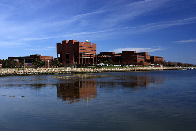
UMass Boston, waterfront campus, leads research on how to respond to coastal sea-rise. Image: wikimedia.
According to the University of Massachusetts Boston, and the Woods Hole Group, options to prevent the damage of flooding include spending $11.8 billion for a macro harbor barrier such as that built in the Netherlands. New York City is also studying the potential for a barrier that might cost $119 billion. In the short-term, Boston will budget $30 million per year to combat sea rise, with new ideas including:
TRANSPORT: New watertight doors on the rail tunnel near Fenway Park; redoing blockage of underground rail ventilation systems near Aquarium MBTA station.
PARKS: Protective berm of 10 feet along shore of Joe Moakley Park, a 60-acre oasis in South Boston near the beach. The park itself will be raised, and chambers installed beneath playing fields that will be capable of holding 5 million cubic feet of storm surge water. Other parks undergoing similar change: Ryan in Charleston on the Mystic River.
BUILDINGS: New condo high-rise housing on Boston Harbor comes with an “aqua fence” or portable flood barrier. General Electric (GE) leased two historic brick buildings, elevating the first floors and moving all electrical equipment to higher levels than the traditional basement.
MUSEUMS AND CULTURAL ICONS: Boston’s Children’s Museum redesigned a lawn into a hill, with a playground surrounded by dense plantings.
FOOD SUPPLY: Most large supermarkets build loading docks below ground; if food supply is to remain available when a city suffers flooding, relocating loading docks could improve public health.
MUNICIPAL PERMITS AND REGULATIONS: New buildings must meet increasing strict environmental standards. A similar approach governs new construction in Paris, France.
INVITING INNOVATIVE IDEAS: Boston’s Museum of Science, with the support of General Motors and Greentown Labs, is holding a $3,000 competition for ideas in transportation to help achieve carbon neutrality.
Museum of Science, Boston, sponsoring Go Carbon Neutral: A Transportation Challenge, 22 April 2020. Image: wikimedia.
Mufson, Steven. “Boston harbor brings ashore a new enemy: Rising Seas: Facing climate change, Boston must gird itself for an era of rising water – or be inundated.” 18 February 2020. The Washington Post. https://www.washingtonpost.com/climate-solutions/2020/02/19/boston-prepares-rising-seas-climate-change/.
Spang, Edward. “Food-Energy-Water Nexus.” Center for Water-Energy Efficiency. 4 May 2017. https://ie.ucdavis.edu/wp-content/uploads/sites/38/2017/05/spang-o3MAY17.pdf.
Spang, Edward., and William Moomaw, Kelly Gallagher, Paul Kirshen, and David Marks. “Multiple metrics for quantifying the intensity of water consumption of energy production.” Environmental Research Letters, vol. 9 (10), 8 October 2018.
Appreciation to Charles E. Litwin, David H. Marks, and Cherie E. Potts for research suggestions.
Building the World Blog by Kathleen Lusk Brooke and Zoe G. Quinn is licensed under a Creative Commons Attribution-NonCommercial-NoDerivs 3.0 Unpo
American cities lost 36 million trees in the last five years. Without trees, cities will get hotter and suffer more periods of air pollution. Why are we losing trees? Hurricanes and tornadoes tear them from the earth, fires burn them to the ground, insects and diseases weaken and kill trees. Those are some of the reasons we can’t easily control.
La Rambla, Barcelona, Spain. Image: wikimedia.
But there is one factor we can influence: city development. Cities are on the rise, rapidly growing into megacities with populations of 10 million or more. The United States, with 80% of the US population living in urban areas, especially in forested coastal regions along the West and East coasts, has a unique opportunity to preserve and enhance urban forests. It’s well worth it. Trees bring environmental and economic benefits.
URBAN TREES:
Provide shade for homes, schools, office buildings, cooling surface temperatures;
Reduce pollution through absorbing carbon and filtering pollutants from the air;
Reduce energy costs by reducing air-conditioning use – economics of $4 billion per year;
Improve water quality by filtering rainwater, absorbing nitrogen and phosphorus in to the ground;
Protect against urban flooding, absorbing surface water;
Reduce noise pollution by absorbing urban sound;
Enhance city soundscape by adding birdsong, and the whisper of wind through leaves;
Protect against UV radiation, absorbing 96% of ultraviolet radiation;
Improve health, physical through cleaner air and shade to exercise outdoors, mental health of being in nature;
The New River passes through Bowes Park. Image: wikimedia.
Case studies of successful historic urban forestation reveal strategies. In the year 1600, so many people crossed London Bridge to live in the burgeoning London town that water supply became strained. One of the world’s first artificial or built rivers combined two elements: drinking water and trees. Constructed from 1605 to 1639, the New River stretches over 20 miles from Hertfordshire to Islington, just uphill from London, terminating in a water reservoir ready as needed. All along the route, tree-lined walking paths add protection and shade. Today, the New River is run by Thames Water PLC, managing water supply, and maintaining the walking paths traversed by urban hikers including the Ramblers Association. It is interesting to note that Hugh Myddleton, who partnered with King James I to build the New River, was the regent’s former jeweler and may be related to a member of the present House of Windsor.
Boston had a similar idea with Olmstead’s “Emerald Necklace” with recent Rose Fitzgerald Greenway extension of the urban breathing ribbon of green. The Greenway replaced what was formerly the Central Artery that ran traffic anthrough town; the road was placed underneath in a tunnel and the surface became a park. For an even earlier urban greening, some would point to the City of the Eiffel Tower where Haussmann widened tree-lined boulevards to breathe air and design into Paris. Presently, the city of light requires new commercial construction to have either solar or living green roofs.
“Terrasse panoramique @ Le Printemps Haussmann @ Paris.” by Guilhem Vellut, 2017. Image: wikimedia commons.
By 2050, 70% of the world’s people will live in cities. As cities grow, rebuilding better water systems, developing flood prevention plans, redesigning roads to accommodate electric and autonomous vehicles, how can trees become part of the plan? Will the proposed Climate Conservation Corps (CCC) plant trees in cities? A pilot project at Roger Williams University, or an initiative by World War Zero, might lead the way. There may be considerations of legal import: should trees have standing?
Biodiversity: the decade of decision. “Mushrooms and diverse fungi of Saskatchewan.” Image: wikimedia.
Decisions made in the next decade may shape the future. In 2020, the United States will hold an important election; Japan will host the Olympics. All eyes on the future. Species, both animal and plant, are disappearing 1,000 times faster than before humans appeared. Earth is threatened by climate change; water is becoming more scarce; and, as Hansjorg Wyss states: “extractive industries chew further into the wild.” Wyss believes there may be an answer: conserve remaining wild lands as public reserves. The world’s first national park (Yellowstone in 1872) opened a new idea of preservation: now, 15% of earth’s land and 7% of the oceans is protected. Wilderness tamed and framed like the National Trails System; greenways like that on Boston’s Central Artery as nature ribboning through cities; rivers granted personhood rights are among the regulatory and legal measures of protection. Edward O Wilson, founder of Half-Earth Day, warns we must preserve half the earth to save the whole. Timing may be urgent: 77% of land on earth has been modified by humans. Wyss pledged $1 billion over the next decade with the goal of protecting 30% of the planet by 2030.When the United Nations Biodiversity Conference convenes in land of the Suez Canal on November 13, 190 countries will seek agreement to preserve the natural systems that support the earth. Here’s a link to include your voice.
Albeck-Ripka, Livia. “Scientists Warn That World’s Wilderness Areas Are Disappearing: ‘Wild areas provide a lot of life support systems for the planet,’ said the author of a study that found 77 percent of earth’s land had been modified by humans.”31 October 2018, The New York Times, https://www.nytimes.com/2018/10/31/world/australia-wilderness-environment-gone.html.
Watson, James E.M., Oscar Venter, Jasmine Lee, Kendall R. Jones, John G. Robinson, Hugh P. Possingham, James R. Allen. “Protect the last of the wild.” 31 October 2018, Nature. https://www.nature.com/articles/d41586-018-07183-6
Wilson, Edward O. Half-Earth: Our Planet’s Fight for Life. 2016. ISBN: 9781631490828.
Building the World Blog by Kathleen Lusk Brooke and Zoe G Quinn is licensed under a Creative Commons Attribution-NonCommercial-NoDerivs 3.0 Unported Licen
Flooding in Dhaka, Bangladesh. Photographer: Gul Cratt, 2006. Image: wikimedia.
Many of the world’s great cities were built as ports, welcoming ships, trade, and opportunity. Singapore is an example. So is New York. Coastal cities must contend with typhoons, hurricanes, rains, and flooding. With climate change, so-called “thousand-year floods” are happening more frequently than such a name might indicate. During Hurricane/Super Storm Sandy, New York saw Wall Street underwater. Another problem? Sea-rise. Here are some of the cities that may suffer inundation: Shanghai, Osaka, Alexandria, Miami, Rio de Janeiro, Amsterdam. Dhaka (19 million) is especially threatened, with danger beyond the capital city: Bangladesh may see 17% of land underwater and 18 million people displaced. Jakarta (10 million) is the fastest-sinking city in the world with 13 rivers merging into Indonesia’s Java Sea on which the coastal capital is located.
Copenhagen rebuilt for climate change . Image: wikimedia
How can coastal cities defend themselves against rising seas and flooding from storms? One approach is rethinking city surfaces from hard asphalt to spongy grass. Copenhagen decided to redesign the city after receiving six inches of rain in two hours during a 2011 storm. Over 300 projects from large parks and greenways, to tiny garden plots with bioswales to absorb rainwater, began the transformation. New York followed suit, forming a partnership with Copenhagen to exchange ideas and measure results. Copenhagen and New York may be cities of different size, but the problems of sea-rise and flooding threaten all coastal cities (and, of course, island states and nations).
But it’s not just physical infrastructure that makes a city resilient. It’s also another kind of infrastructure: governance. The Sustainable Solutions Lab (SSL) in a 2018 report “Governance for a Changing Climate: Adapting Boston’s Built Environment for Increased Flooding” recommended a joint state-municipal commission to deal with increasing climate impact. Governance suggested: 1) reform existing tools including acts and laws; 2) coordinate water/sewer, transport, energy, and telecommunications to a common standards; 3) combine scientists and government agencies in a climate advisory team; 4) establish governance and district-scale flood protection. University of Massachusetts Boston Sustainable Solutions Lab‘s previous reports on Boston included financing solutions to climate change, and a feasibility study of harbor barriers.
Governance for a Changing Climate: Adapting Boston’s Built Environment for Increased Flooding. Sustainable Solutions Lab. Image: Boston’s Zakim Bridge.
Coastal cities might look to Boston’s approach as one model that cities can enact. Cities have a unique capability to address climate change.
According to Michael Bloomberg, three-time mayor of New York, cities can respond faster to climate change because they can pass laws quickly, decide upon structural change, fund urban design initiatives, and coordinate governance. The Global Covenant of Mayors, representing 9,149 cites housing 780,804,596 people worldwide, signed a Climate & Energy agreement to bring cities together to respond to climate change. Bloomberg and European Commission Vice-President Maroš Ṧefcovič co-chair the board; Christiana Figures, architect of the Paris Agreement and founder of Global Optimism, serves as vice-chair. The mission combines initiatives with inclusion to achieve a just, low-emission, resilient future. Cities may be the first responders to climate change.
Building the World Blog by Kathleen Lusk Brooke and Zoe G Quinn is licensed under a Creative Commons Attribution-NonCommercial-NoDerivs 3.0 Unported License
“Night lapse of the 401” by Kennymatic, 2008. Image: wikimedia
Road ahead? Concrete decisions may determine the future of cities. Many urban centers are opting for surface transport: whether fuel-powered or electric, whether driven or driverless, whether bicycles or pedestrians, the future looks paved. Rome built its legendary roads with a special concrete strengthened by a mix-in of volcanic ash; in modern times, basaltic rock has shown to be effective carbon dioxide absorbent, turning the unwanted gas into stone so hard it’s being used to build roads, and towers. So settled on surface are some cities that even New York City, where the subway is in need of expensive repair, may consider just paving over the tunnels for underground vehicular lanes. It was in 1939, at the World’s Fair, that General Motors showcased the concept of “magic motorways” and in 1956, Dwight D. Eisenhower, when returning from Germany where the general had glimpsed the Autobahn, opened U.S. Federal Highway System for bidding.
Buffalo Metro Rail Station, Niagara Frontier Transportation Authority, New York. Image: wikimedia commons
Rail, known to be the fastest and most environmentally efficient way to move people, and goods, may be better. Las Vegas is betting on light rail: the $750 million project will bring trains along a route named the Maryland Parkway; real estate development is planned to link, and the stops will include Sunrise medical area and UNLV. It can be noted that former UNLV president, Don Snyder, serves as chair of the community advisory group. Then there’s the Windy City, where a plan to run a Chicago HyperLoop to O’Hare Airport, inked by Mayor Ron Emanuel and HyperLoop Advocate Elon Musk, may zoom from midtown to out of town in just 12 minutes.
Transport systems are expensive, and need to be rebuilt when in disrepair. Many existing roads and bridges are crumbling in highway systems that need repair. Cities have the power to determine transport: linking public transit to affordable housing, or community educational and medical facilities, must be part of the plan. The United States may spend a considerable sum to rebuild American transport infrastructure; what is your vision?
Badger, Emily. “Pave Over the Subway? Cities Face Tough Bets on Driverless Cars.” 20 July 2018. The New York Times.
Marroquin, Art. “Light-rail line could spur development along Maryland Parkway.” 19 June 2018. Las Vegas Review-Journal.
Building the World Blog by Kathleen Lusk Brooke and Zoe G Quinn is licensed under a Creative Commons Attribution-NonCommercial-NoDerivs 3.0 Unported License
Every era of civilization might be characterized by its predominant mode of transport; perhaps the Internet is the road of our time, it’s new fast lane: 5G. Three decades after COMSAT launched satellites, AT&T began developing an industry standard for interoperability of wireless communication with partner Nortell. As a result, GSM became the standard. Today’s interoperability certification is TETRA. The result? Driverless cars, smarter cities. Should the United States Interstate System open a tetra lane for autonomous vehicles? The Critical Communications Association (TCCA), coordinating public safety and disaster response, might suggest, next to the tetra lane, a sportsway with charging stations, segway and bike lanes, and walking routes. Boston might consider building the first link, in cooperation with the Central Artery, part of the Interstate: nickname, 5Greenway.
Instant takes time. The first idea for 5G dates to April 2008 when NASA and Machine-to-Machine Intelligence (m2mi) partnered, termed by some as the “commercialization of space.” The Memorandum of Understanding was only the third in NASA’s history. Stated goals included: “Under the agreement, NASA and m2mi will cooperate to develop a fifth generation telecommunications and networking system for internet protocol-based and related services. The cooperative effort will combine NASA’s expertise in nano sensors, wireless networks, and nano satellite technologies with m2mi’s unique capabilities in software technology, sensors, global system awareness, adaptive control and commercialization capabilities. Fifth Generation, of 5G, incorporates Voice Over Internet Protocol, video, data, wireless, and an integrated machine-to-machine intelligence layer, or m2mi, for seamless information exchange and use.” In December 2017, 5G was approved by the 3GPP international wireless consortium. The United Nations’ International Telecommunications Union will consider the system in 2019.
Next Olympics: 2020 Tokyo. Japan launched high speed train system Shinkansen for the opening of the 1964 Olympics. Speed has always been a winning characteristic of Olympic gold. What kinds of speed, including 5G, will we see in 2020?
Building the World Blog by Kathleen Lusk Brooke and Zoe G Quinn is licensed under a Creative Commons Attribution-NonCommercial-NoDerivs 3.0 Unported License
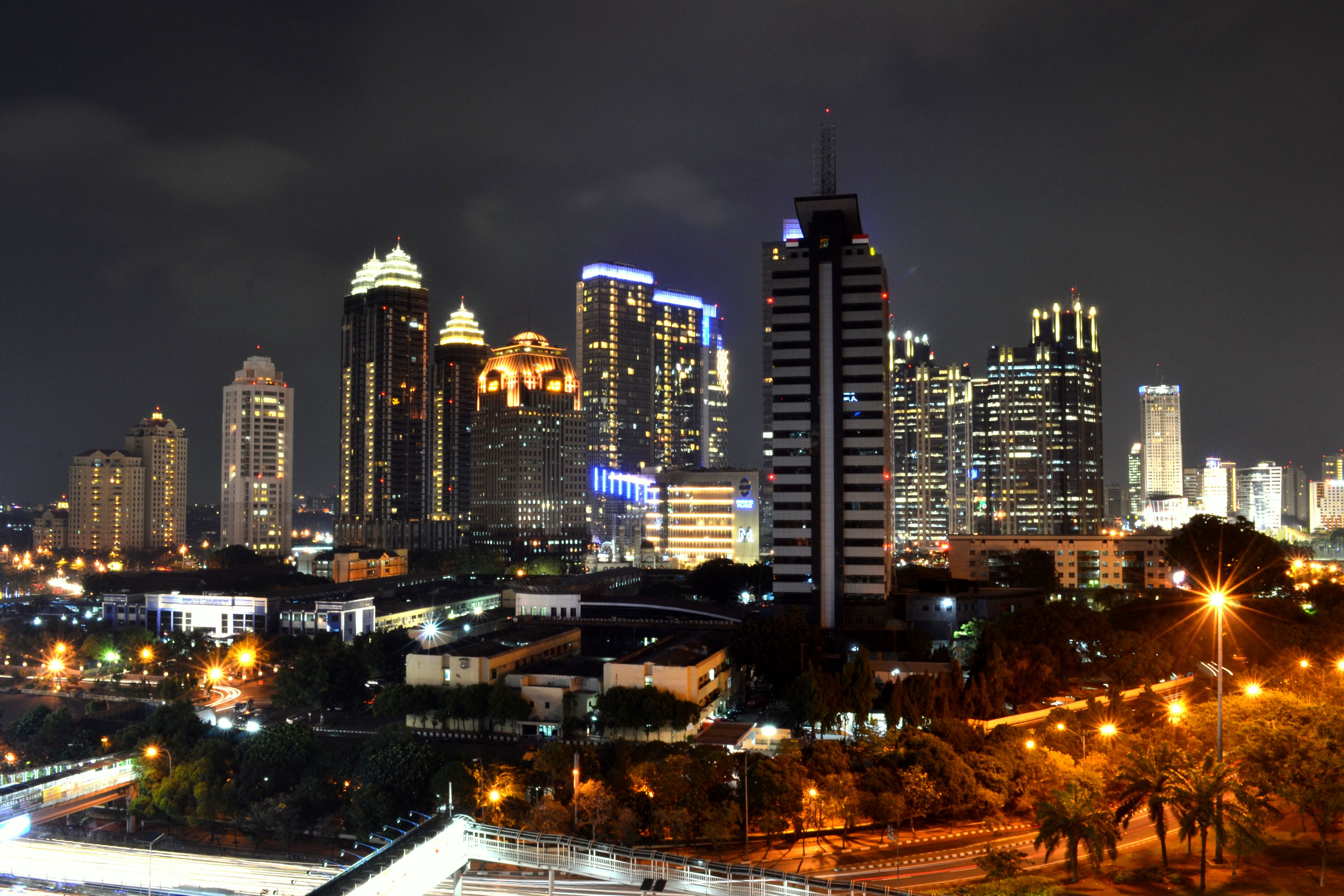
Jakarta: originally Jayakarta or “Victorious City.” Muhammad Rashid Prabowo, photographer, Wikimedia commons.
Jakarta is sinking; sections of Indonesia’s capital city have lost 2 inches per year. Buildings in this dense city of 10 million people weigh down coastal land. Residential and business development increased demand for drinking water. Drilled wells, legal and illegal, caused the city to sink further. Draining urban underground aquifers is “like deflating a giant cushion.” Experts warn Jakarta must fix the problem within this decade. Climate change is worsening the situation: sea-rise could bring water even closer, as much 36 inches. Other cities may take note. Subsidence plagues Mexico City, built on a drained lakebed. Boston, shaped by landfill, contends with subsidence as well as sea-rise. New York is vulnerable to storm surge. The Erie Canal linking New York to the Great Lakes may hold promise as inland waterways play a new role in water protection. Inland Waterways International may offer innovations. Coastal cities might find guidance from the Urban Harbors Institute in Boston. The East Coast of the United States is particularly vulnerable to sea-rise because of the steep sea-level slope just offshore that keeps the Gulf Stream channeled. Climate scientists place New York, Boston, Norfolk, Ft. Lauderdale, and Miami on the watch list. Put a price on it? Coastal storm “Sandy” flooding New York and New Jersey in 2012 cost $50 billion. Sea-level rise brings inundation, flooding, erosion, wetlands loss, saltwater intrusion, and damaged sanitation systems. Meanwhile, Jakarta is sinking faster than any city on the planet. As goes Jakarta, so may go other coastal communities. When the problem is solved, Jakarta will give new meaning to its original Javanese name: Jayakarta or “Victorious City.”
Brown, Sally, Robert J. Nicholls, Collin D. Woodroffe, Susan Hanson, Jochen Hinkel, Abiy S. Kebede, Barbara Neumann, Athanasios T. Vafeidis. “Sea-Level Rise Impacts and Response: A Global Perspective.” Coastal Hazards, edited by Charles W. Finkl. Springer, 2013. http://www.springer.com/us/book/9789400752337/.
Crowell, Mark, Jonathan Westcott, Susan Phelps, Tucker Mahoney, Kevin Coulton, Doug Bellow. “Estimating the United States Population at Risk from Coastal Flood-Related Hazards.” Coastal Hazards, edited by Charles W. Finkl, pp. 245-66. Springer. DOI:10.1007/978-94-007-5234-4.
Kemp, Andrew C. and Benjamin P. Horton. “Contribution of relative sea-level rise to historical hurricane flooding in New York City.” Journal of Quaternary Science 28.6:537-541.
Yin, Jianjun, Michael E. Schlesinger, ad Ronald J. Stouffer. “Model projections of rapid sea-level rise on the northeast coast of the United States.” Nature Geoscience. 15 March 2009. DOI:10.1038/NGEO462. http://www.meteo.mcgill.ca/~huardda/articles/yin09.pdf
Building the World Blog by Kathleen Lusk Brooke and Zoe G Quinn is licensed under a Creative Commons Attribution-NonCommercial-NoDerivs 3.0 Unported License
Denmark, state banner from 14th century, location of world’s first vehicle-to-grid (V2G) commercial charging station. Image: wikimedia commons.
Batteries in electric cars could help to balance the grid. In 2017 electric vehicles drew 6-terawatt-hours; by 2040, draw will expand to a predicted 1,800 terawatt hours. Tokyo-based automaker Nissan is conducting trials in Denmark where car fleet operators earn $1,530 (€1300 Euro) per year via two-way charge points. Vehicle-to-grid (V2G) infrastructure could be a sign of the future. Major highway systems take note.
It may be time for a systems view of electric vehicles, predicted to account for 54% of new car sales by 2040, Electric cars will transform highways like the U.S. Interstate Highway system – more than 45,000 miles, and even more dramatically the service areas nearby. Should the Pan-American Highway, 30,000 miles from Alaska to Argentina, be the first to offer a network of V2G? Canada and the United States could rebuild the Alaska Highway for a new era. On a local level, commuter rail stations are adding charging stations; shopping centers are dotted with ChargePoint and Tesla pods. Every one of these installations is an opportunity for rebuilding the automotive energy system.
If the Nissan/Enel/Nuvve commercial vehicle-to-grid hub of 10 stations proves successful, Ernesto Ciorra of Enel predicts: “With V2G we can enhance grid stability, further enabling the integration of renewables. V2G is one of the sustainable innovation areas that is taking us towards a low-carbon society for the benefit of present and future generations.” As the number of electric vehicles increases is the future of gridlock, grid luck?
Building the World Blog by Kathleen Lusk Brooke and Zoe G Quinn is licensed under a Creative Commons Attribution-NonCommercial-NoDerivs 3.0 Unported License
A higher purpose, above ground; a safer world, below. Why not send cars and trucks underground, where new roads for autonomous vehicles might be easier to build? Elon Musk, of Tesla and SpaceX fame, envisions cars positioned on platforms that descend to traverse networks below ground. A similar design was earlier suggested by David Gordon Wilson of MIT whose palleted highways would increase speed and decrease accidents. Tunnels have changed transport around the world: the Channel Tunnel and the Mount Blanc Tunnel are recent examples. Boston depressed the Central Artery, resulting in a Greenway atop with a special park called the Mothers’ Walk. Nearby, walk towards a better world with the Louis D. Brown Peace Institute for the Mother’s Day Walk for Peace. Will Elon Musk’s underground highways promote a cleaner, safer environment with more parks above where people can walk and nature flourish? It’s an exciting idea with a name that belies the innovation: The Boring Company.
Building the World Blog by Kathleen Lusk Brooke and Zoe G Quinn is licensed under a Creative Commons Attribution-NonCommercial-NoDerivs 3.0 Unported License.