
What is a benthic habitat map?
"A benthic habitat map is a "spatial representation of physically distinct areas of the seafloor that are associated with particular groups of plants and animals"
-Harris and Baker. 2012. Seafloor Geomorphology as Benthic Habitat. GeoHAB Atlas of Seafloor Geomorphic Features and Benthic Habitats, 1st ed, Elsevier, Amsterdam; Boston
What do benthic habitat maps tell us?
- Summarize the physical and biological resources of a region
- Species distribution and abundance
- Water and habitat quality
- Changing ecological communities and document invasive species
- Fisheries resources
Why are benthic habitat maps important?
- Support informed decisions about managing our coastlines
- Long-term monitoring
- Baseline for future storm or pollution events
- Identify critical/sensitive habitats
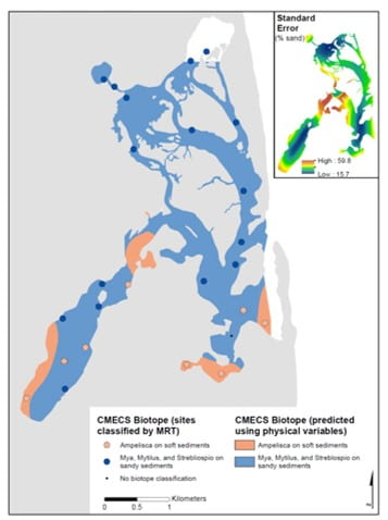
Coastal and Marine Ecological Classification Standard (CMECS)

CMECS is a comprehensive national framework for organizing information about coasts and oceans as well as their living systems. It classifies the environment according to four components: Water column, Geoform, Substrate and Biotic component.
Our physical and biological data is fed into the CMECS framework to describe the biotopes or distinct ecological/physical communities found along the New England coast. Using CMECS enables us to compare local biotopes nation wide.
CMECS is an ongoing collaborative effort, more information click here.
What is CMECS?
- Simple framework to describe natural and human influenced marine environments
- Combines biological, geological, chemical and physical data
- Complies with Federal Geographic Data Committee standards
- Flexible (accepts many types of data)
- A powerful common language that allows data to be compared across regions
How does CMECS work?
Here is an example of how CMECS classifies station 14 in East Harbor, Truro, MA. Click here to learn more about East Harbor.
Water Column Component
Layer: Estuarine Coastal Lower Water Column
Salinity Regime: Upper Polyhaline
Temperature Regime: Moderate
Biotic Component
Setting: Benthic/Attached Biota
Class: Faunal Bed
Subclass: Soft Sediment Fauna
Group: Small Tube-building Fauna
Community: Syllid Bed

Substrate Component
Origin: Geologic Substrate
Class: Unconsolidated Mineral Substrate
Subclass: Coarse Unconsolidated Substrate
Group: Gravelly Sand
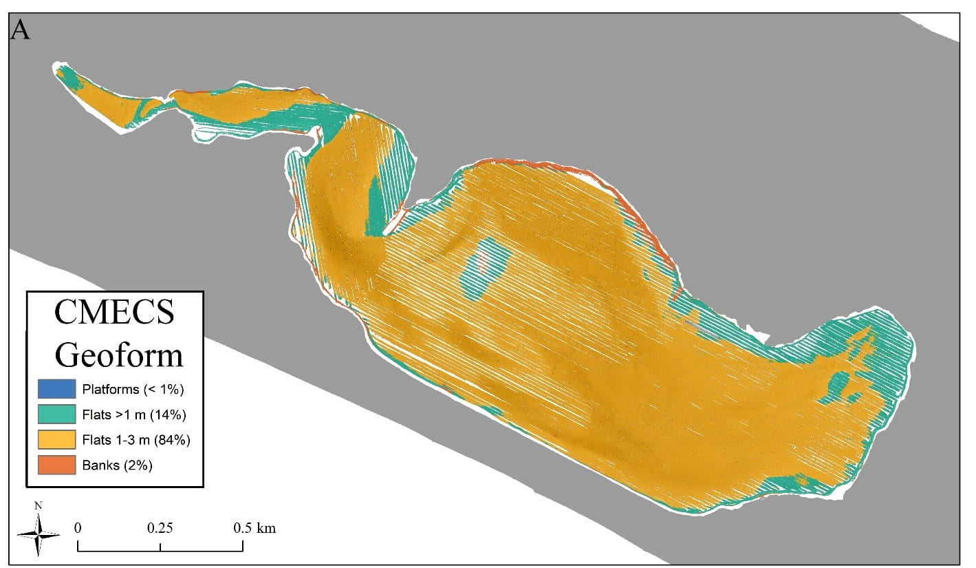
Geoform Component
Tectonic Setting: Passive Continental Margin
Physiographic Setting: Lagoonal Estuary
Geoform Level 1: Barrier Flat
Geoform Level 2: 1-3m deep
Projects involving Benthic Habitat Mapping:
Barnstable Harbor
Long Race Disturbance Study
Shimmo Creek
East Harbor
Pleasant Bay
Nauset Marsh
Wellfleet Harbor
Provincetown Hook