
View Calf Pasture Pumping Station in a larger map
This map shows sites related to the Calf Pasture Pumping Station, including:
- the Calf Pasture Pumping Station (no longer in operation) – which includes locations of Shaft Entrance building and Switchhouse as well as main Pumping Station building
- the Moon Island facility in Quincy, MA (no longer in operation)
- the Nut Island sewage treatment facility in Quincy, MA (currently in operation)
- the Deer Island sewage treatment facility in Boston Harbor (currently in operation)
Moon Island

(Source: Clark, Eliot C. Main Drainage Works of the City of Boston, 1888.) (Click to enlarge image)
The City of Quincy housed the Moon Island sewerage facility. Moon Island served as the final destination for Boston’s sewage until 1968 when the city updated the Deer Island facility to handle the main drainage sewage. Reservoirs on Moon Island collected the raw sewage transported from the Calf Pasture Pumping Station. Here, reservoirs held sewage until releasing it into Boston Harbor with the outgoing tide.
Decades of dumping the city’s untreated sewage had negative impacts on Boston Harbor and local communities. Attempts to redress this pollution began In 1941, with the design of a waste treatment facility at Nut Island. Ernest efforts to clean the harbor began in the 1970s.
Nut Island
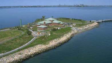
(Source: Massachusetts Water Resources Authority). (Click to enlarge image)
It took seven years to build the sewerage treatment plant at Nut Island, in the City of Quincy; construction began in 1945, and operations commenced in May 1952. Total construction costs were approximately $10 million.
Engineers designed the Nut Island sewerage facility to address environmental problems created by the release of untreated sewage into Boston Harbor. The Nut Island plant built in 1952 could not provide sufficient sewage treatment to protect the waters of Boston Harbor, however. Prompted by a lawsuit and investigation in 1982, the 1952 facility at Nut Island was demolished, and a new Nut Island Headworks facility opened in 1998. This newer facility can complete a secondary treatment of sewage, and thus remains in operation today. The Massachusetts Water Resource Authority maintains a public park on the island.
Deer Island
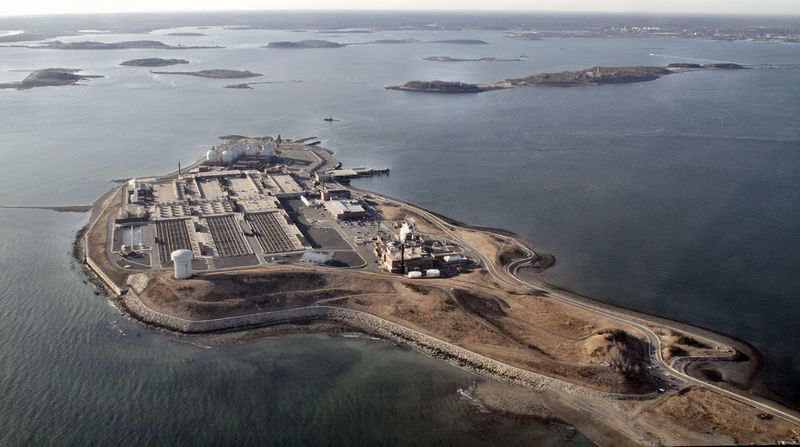
(Source: Doc Searls via Creative Commons) (Click to enlarge image)
The facility on Deer Island in Boston Harbor is perhaps the most easily recognizable sewerage treatment plant in Boston. The distinctive large round tanks are readily spotted from airplanes, boats, and land across the harbor. The first primary treatment plant at Deer Island was built in 1968. In 1982, the establishment of the Massachusetts Water Resources Authority (MWRA) led to the rehabilitation of sewerage treatment facilities on both Nut Island and Deer Island to create plants that could sufficiently treat Boston’s sewage for safe release into the Harbor.
Sources Consulted:
- Massachusetts Water Resources Authority
- Kennison, Karl R. “Sewage Works Development in the Massachusetts Metropolitan District.” Sewage and Industrial Wastes 22.4 (1950): 477-89. JSTOR. Web. 06 Mar. 2013.
- Hanlon, Joseph B. “Screenings and Grit Complicate Starting Operations at Nut Island Sewage Treatment Plant.” Sewage and Industrial Wastes 26.10 (1954): 1290-1301. JSTOR. Web. 06 Mar. 2013.
- Flynn, Kevin C. “Turning the Tide in Boston Harbor.” Water Pollution Control Federation. 57.11 (1985): 1048-1054. JSTOR. Web. 06 Mar. 2013.
Photo Credits:
- Map hosted by Google Maps
- Clark, Eliot C. Main Drainage Works of the City of Boston
- Massachusetts Water Resources Authority
- Massachusetts Water Resources Authority