Inside the Abandoned Pumping Station

The original entrance to the Calf Pasture Pumping Station, 2011. (Click to enlarge image)

Since its closure as an active pumping station in the late 1960s, the Calf Pasture Pumping Station has been neglected. Currently, most windows are boarded up and a high fence surrounds the property as the various institutions on Columbia Point build and expand.  The beauty of the building and the mystery of the inaccessible have led many people to wonder what the interior looks like.  

UMass Boston’s Associate Provost Peter Langer toured the inside of the building in 2011, and took these photographs.  

An interior view of the Calf Pasture Pumping Station, 2011. (Click to enlarge image)
Some of the old pieces of equipment can still be seen, 2011. (Click to enlarge image)

Several others have  had access to the building, and recorded the building’s interior.   Late in 2008, an artist entered the building, and  documented their visit on the website Desolate Metropolis.

Have you been inside the Calf Pasture Pumping Station?  Do you have observations or pictures?   Please share these with us in the comments section below.   in the comments below?  

Early Sanitation in Boston and the Evolution of Modern Sewerage Systems

Prior to the development of sophisticated sewerage systems like the one that Boston created in the 1870s, urban water supplies posed a significant health risk to residents. Water-borne illnesses such as cholera, dysentery and typhoid  thrived in the unsanitary conditions that came with dense urban living before modern sanitation. Between 1846 and 1863, several cholera outbreaks struck India, then the Middle East, then Europe and Africa, before making their way to the United States. Estimates suggest that these outbreaks  resulted in a total of over one million deaths .

An 1849 map showing the spread of cholera through Boston. (Click to enlarge image)

In the large towns of colonial America during the 17th century, the earliest residents often had a privy at ground level that discharged directly into the street, usually with an open gutter or channel serving as a sewer. Occasionally, privies led to cesspools or vaults which stored the waste until it could be disposed of or until it soaked into the groundOften, however, waste  remained in the streets, in contact with food and water sources, wandering livestock and human feet.   By the 19th century, many urban areas had adopted a dry sewerage system in which residents transported the contents of their privies to a designated area in order to try and stave off widespread contamination.

King Cholera

“King Cholera”, an illustration of unsanitary urban conditions at the time of the outbreak. (Click to enlarge image)

In 1848, over three hundred Italian immigrants who had been exposed to the cholera virus arrived by ship in New York City. Although there were some attempts at quarantine, the city had not seen an cholera outbreak in fifteen years and was unable to contain the virus. Within months, the cholera pathogens spread from New York City to Boston. The disease spread rapidly through the newly crowded cities, sending residents and public officials into a panic.

In Boston, the mayor issued a public announcement advising people to practice hygiene and instructing them to collect waste and rubbish on particular days so that the city could systematically dispose of it. Newspapers published articles on the symptoms of cholera and treatments for it. Nonetheless, the toll taken on the city was significant.

The mayor’s announcement to Boston residents, bringing attention to sanitation issues. (Click to enlarge image)

After the outbreak of 1849, and the following outbreak of 1866, Boston began to look towards an overhaul of  the sewerage system to modernize the city and protect its residents from disease. By 1875, Boston had launched a study to  research pollution and water contamination causing health issues including cholera, typhoid and dysentery.   The study prompted a newly designed sanitation system, which was completed and functional by 1884; this system included the Calf Pasture Pumping Station Complex, and the Moon Island treatment facility. This investment in public health had a huge impact on curtailing the spread of waterborne diseases in the city and brought Boston into the modern age of sanitation.

Sources Consulted:

  1. Burian, Steven, Stephan J. Nix, Robert E. Pitt, and S. Rocky Durrans. “Urban Wastewater Management in the United States: Past, Present, and Future.”Journal of Urban Technology. no. 3 (2000): 33-62.
  2. Centers for Disease Control and Prevention, “Cholera-Vibrio Cholerae Infection .” Last modified 5 21, 2012. http://www.cdc.gov/cholera/prevention.html.
  3. Rosenburg, Charles. The Cholera Years: The United States in 1832, 1849, and 1866. Chicago: University of Chicago Press, 1987.

Photo Credits:

  1. Cholera Map – http://www.historyofvaccines.org/content/cholera-boston-1849
  2. “King Cholera” – http://www.victorianweb.org/science/health/cholera.html
  3. Cholera Announcement – http://www.flickr.com/photos/cityofbostonarchives/4479753024/in/photostream/

Deciding the Future of the Calf Pasture Pumping Station

As Boston grew and its residents learned the dangers of pollution, they understood the problems resulting from the release of sewage into the harbor at Moon Island.   Bostonians called for a cleaner harbor, and by the 1960s and 1970s treatment of sewage was rerouted to Deer Island.

But the Boston Water and Sewer Commission still used the Calf Pasture Pumping Station on occasion.  In the 1970s, during heavy rains,  excess street water was channeled to the pumping station, where it was treated behind the station, on the side of the building that faces the UMass Boston campus.  Eager to end such use on their campus, in 1999, university administration began negotiations to purchase the property.  

The Boston Water and Sewer Commission was reluctant to give up the Calf Pasture Pumping Station, because they would have to build a new facility somewhere else in the Boston area.  Local politicians took up the debate.  After a dozen years, in 2012 the university finally reached an agreement with the city and the Boston Water and Sewer Commission, and purchased the pumping station.  

What is the future of the Calf Pasture Pumping Station at the University of Massachusetts Boston?  How can it be used?  Many faculty members and administrators have made suggestions for  possible re-use of the building. There are many challenges to conquer before renovation can occur.  These include environmental remediation at the site, and completing a structural report to assess the work needed to reuse the space.  

Recently the University released a large twenty-five-year plan for renovations to the UMass Boston campus, but the pumping station is not included in this plan.  The university did not yet own either the Calf Pasture Pumping Station or the Bayside Expo Center in 2007, when the 25 Year Master Plan was unveiled  

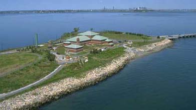
Today, major redesign of the UMass Boston campus and the construction of new buildings and roadways  are underway.  In the new design, a new street will bring visitors in front of the majestic Calf Pasture Pumping Station, though its future use remains uncertain.  

At present, boarded up windows and fencing secure the pumping station against general access.  At the front of the building, construction of a new roadway has commenced, and the university prepares to build its first residential complex near the site.  

Rehabilitation, preservation and reuse of the Calf Pasture Pumping Station will require great financial resources as well as vision.  This historic structure, its historical and architectural significance documented by a National Historic Register nomination, remains at risk.  The physical condition of the building continues to deteriorate, as local development and the need for space put additional pressure on this historic site.  

The Calf Pasture Pumping Station provides us with access to multiple stories of the past that have relevance to the present.  It engages histories of  technology, architecture, public works, public health, labor, environment, neighborhood, housing, and politics.

What ideas do you have for bringing these histories into the present, for the benefit of Boston’s citizens?  What histories matter to you?

Boston Sewerage Past and Present: Other Local Treatment Facilities


View Calf Pasture Pumping Station in a larger map

This map shows sites related to the Calf Pasture Pumping Station, including:

  • the Calf Pasture Pumping Station (no longer in operation) – which includes locations of Shaft Entrance building and Switchhouse as well as main Pumping Station building
  • the Moon Island facility in Quincy, MA  (no longer in operation)
  • the Nut Island sewage treatment facility in Quincy, MA (currently in operation)
  • the Deer Island sewage treatment facility in Boston Harbor (currently in operation)


Moon Island

The reservoirs on Moon Island where the untreated sewage from the Calf Pasture Pumping Station was held until it was released into the Harbor.
(Source: Clark, Eliot C. Main Drainage Works of the City of Boston, 1888.) (Click to enlarge image)

The City of Quincy housed the Moon Island sewerage facility. Moon Island served as the final destination for Boston’s sewage until 1968 when the city updated the Deer Island facility to handle the main drainage sewage.  Reservoirs on Moon Island collected the raw sewage transported from the Calf Pasture Pumping Station. Here, reservoirs held sewage until releasing it into Boston Harbor with the outgoing tide.

Decades of dumping the city’s untreated sewage had negative impacts on  Boston Harbor and local communities.  Attempts to redress this pollution began In 1941, with the design of a waste treatment facility at Nut Island. Ernest efforts to clean the harbor began in the 1970s.


Nut Island

Aerial shot of the Nut Island facility in Quincy, MA. (Source: Massachusetts Water Resources Authority)
Aerial shot of the Nut Island facility in Quincy, MA.
(Source: Massachusetts Water Resources Authority). (Click to enlarge image)


It took seven years to build the sewerage treatment plant at Nut Island, in the City of Quincy; construction began in 1945, and operations commenced in May 1952.  Total construction costs were approximately $10 million.  

Engineers designed the Nut Island sewerage facility to address environmental problems created by the release of untreated sewage into Boston Harbor.  The Nut Island plant built in 1952 could not provide sufficient sewage treatment to protect the waters of Boston Harbor, however.  Prompted by a lawsuit and investigation in 1982, the 1952 facility at Nut Island was demolished, and a new Nut Island Headworks facility opened in 1998.  This newer facility can complete a  secondary treatment of sewage, and thus remains in operation today. The Massachusetts Water Resource Authority maintains a public park on the island.


Deer Island

Aerial view of Deer Island in Boston Harbor, home of currently operating sewerage treatment facilities for Boston.
(Source: Doc Searls via Creative Commons) (Click to enlarge image)

The facility on Deer Island in Boston Harbor is perhaps the most easily recognizable sewerage treatment plant in Boston. The distinctive large round tanks are readily spotted from airplanes, boats, and land across the harbor.  The first primary treatment plant at Deer Island was built in 1968.  In 1982, the establishment of the Massachusetts Water Resources Authority (MWRA) led to the rehabilitation of sewerage treatment facilities on both Nut Island and Deer Island to create plants that could sufficiently treat Boston’s sewage for safe release into the Harbor.  


Sources Consulted:

  1. Massachusetts Water Resources Authority
  2. Kennison, Karl R. “Sewage Works Development in the Massachusetts Metropolitan District.” Sewage and Industrial Wastes 22.4 (1950): 477-89. JSTOR. Web. 06 Mar. 2013.
  3. Hanlon, Joseph B. “Screenings and Grit Complicate Starting Operations at Nut Island Sewage Treatment Plant.” Sewage and Industrial Wastes 26.10 (1954): 1290-1301. JSTOR. Web. 06 Mar. 2013.
  4. Flynn, Kevin C. “Turning the Tide in Boston Harbor.” Water Pollution Control Federation. 57.11 (1985): 1048-1054. JSTOR. Web. 06 Mar. 2013.

Photo Credits:

  1. Map hosted by Google Maps
  2. Clark, Eliot C. Main Drainage Works of the City of Boston
  3. Massachusetts Water Resources Authority
  4. Massachusetts Water Resources Authority


Inside the Calf Pasture Pumping Station, 1888.

View of the Shaft building and Pumping Station circa 1880's. Photo from Main Drainage Works of Boston and its Metropolitan Sewerage District.
The shaft building and Pumping Station circa 1880’s.
(Source: Eliot C. Clarke, Main Drainage Works of the City of Boston, 1888.) (Click to enlarge image)

Boston’s new sewerage system, built in  the 1870s and 1880s, was designed to take waste from the city and dispose of it miles away from the local population. The map below shows the newly constructed sewers that drained into the one sewer that led down to the Calf Pasture. Gravity allowed waste to travel from downtown Boston neighborhoods that sat on higher land, to Dorchester’s Calf Pasture on a lower elevation.

After the sewage reached the Calf Pasture Pumping Station, it still had a great distance to travel before reaching its final destination, Moon Island, west of the peninsula in Quincy Bay. To make the last leg of this journey, the station’s massive pumps  lifted the sewage thirty-five feet to enable its journey away from the heavily populated city, past the oscillating tides, towards Moon Island.


This map shows the intercepting sewer that was built to take waste away from the old harbor outlets. (Click to enlarge image)
The layout of the interior of the Calf Pasture Pumping Station. (Click to enlarge image)

What’s in the pumping station?  How does it work?  An 1888 blueprint of the building illustrates the various functions of the large building.  

The coal house held giant bins to store the coal  that created steam power to run the boilers and power the integral pumps.  The pumping station was large enough to store 2,500 tons of coal at once, since the pumping station burned over six tons of coal each day.  Ships docked nearby on the peninsula to deliver new coal shipments to the pumping station’s elevated coal run.

This huge measure of coal fueled two major Leavitt pumps, which ran continuously throughout the day. Each engine could  pump up to 25 million gallons of sewage per day. In the mid-1880s, the two engines pumped an average of just under 37 million gallons each day.

One of the two main pumps which propelled the sewage up and out to complete its journey to Moon Island. (Click to enlarge image)

In some cases, excess storm water pushed the pumps to their limits. In preparation for this possibility, the engineers installed two additional emergency pumps. These two smaller storm duty pumping engines were used sparingly, because they were less fuel efficient than the major Leavitt engines.  Still, they proved crucial when unexpected amounts of water came through the station.  

The two large main pumps and the two smaller back-up pumps housed inside the Calf Pasture Pumping Station.(Click to enlarge image)


Sources Consulted:

  1. “The Boston Sewer System and Main Drainage Works.”Scientific American. no. 28 (1887): 351.
  2. Clarke, Eliot C. Main Drainage Works of the City of Boston. Boston: Rockwell & Churchill, 1888.

Photo Credits:

  1. Clarke, Eliot C. Main Drainage Works of the City of Boston. Boston: Rockwell & Churchill, 1888.