A guest blog by J. Cedric Woods, PhD
Director, Institute for New England Native American Studies, UMass Boston
 Growing up in Robeson County, North Carolina, particularly as a Lumbee Indian, I always knew the Lumber River, our river, was the dominant part of our landscape. It shaped a significant part of our history, serving as a source of food, recreation, and refuge during times of war.
I also knew that as heavily as we relied on it, it had the potential to cause great distress as well. I had seen it flood its banks and some of our roads as a child, and knew that it earned its older name “Drowning Creek.”
However, none of this prepared me for what I experienced in October 2016 with Hurricane Matthew. Hurricane Matthew was expected to bring lots of rain and wind to the region. But the damage that followed was not caused exclusively by its impact. According to the News and Observer, on September 28, a series of freak storms occurred in three counties that lie in the Lumber River basin. Cumberland, Moore, and Hoke counties were hammered with up to 10 inches of rain that fell overnight.
These storms caused the Lumber River to rise more than 6 feet, to at least 2.5 feet above flood stage (approximately 15.5 feet). By October 8, as Hurricane Matthew arrived, the river was only down to its flood stage, 13 feet.
According to the Weather Service, Matthew brought an additional 10-14 inches of rain, where we expected 5 to 8 inches. This led to the Lumber River peaking at around 22 feet-9 feet about flood stage.
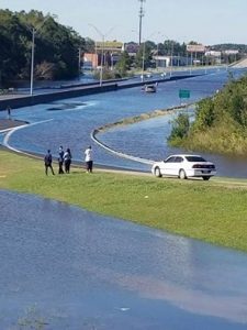
This combination of storms in a short period of time proved overwhelming for Lumberton’s dike and canal systems. The water had no place left to go, so it ran over berms, dams, and bridges. It flooded many of Lumberton’s public housing developments and some of its Section 8 rent-assisted apartments where the most vulnerable members of its citizenry lived. And, like the surrounding county, these citizens of the city were from its diverse white, African American, and Native American populations.
This storm didn’t just impact the largest city in the county, but its rural areas as well. More than a thousand people took refuge in shelters, with Purnell Swett High School having the largest number.
Major highways, like Interstate 95, numerous county roads, and unpaved dirt roads leading to the many trailers and rural houses were closed, damaged, or completely washed out. This made ordinary activities like getting to your home, buying groceries, and going to work (if your employer was still in business) much more difficult.
Even in the best of times, it is hard for many residents of Robeson County. We have a 33% poverty rate and a per capita income of $15,460 (U.S. Census Bureau). The unemployment sits at 7.2 percent. The flooding closed many businesses, so those people lucky enough to have jobs where lost wages. With the power out for days, folks also lost the food in their freezers-vegetables and meat raised and frozen to stretch their budgets.
In spite of longstanding high poverty rates in the county, many of the residents owned their own homes. Following Matthew and the damage from water and mold, many of these homeowners lost their biggest asset, as the support given by FEMA was enough for full remediation.
During and after the storm, it became clear that some towns didn’t have functional distribution centers for emergency supplies. Emergency services communications to residents were extremely limited (loss of power and downed phone lines made reverse 911 impossible). Additionally, the Lumbee Tribe was not integrated into any emergency planning for the county even though tribal members are the majority of county’s population. However, tribal government, Native community organizations, and churches played an important role in servicing the primarily rural Indian communities by running shelters and distribution centers critical to relief efforts.
Community organizations such as churches, fraternal associations, the Lumbee Tribe, and others, seemed to mobilize more meals, propane deliveries, and other supplies than local government agencies. Seeing this effort was one of the few bright spots of this catastrophe. The capacity of these organizations as revealed during this crisis should become part of future disaster planning and recovery. As a result of external and heretofore undeveloped internal networks, what was terrible could have been much, much worse.
In spite of this environmental disaster, and ongoing challenges, I am confident community leaders are working hard to mitigate future damage from similar flooding. There is now the possibility for innovative use of housing/insurance funds to rebuild public housing in areas less prone to flooding, particularly given that what happened with Matthew might be our new “normal” (NC has had two 500 year floods in 17 years). The Lumbee Tribe has its own housing program, which will hopefully incorporate lessons learned from Matthew in planning new housing developments.
It is my hope that going forward, we can build on these newfound connections and alliances to get to a new normal that is more resilient than the old and lays the foundation for a more realistic assessment of what may come next, given the impact of climate change, our river, and the storms to come.
This blog was informed by the local newspaper, the Robesonian, and numerous Facebook posts by relatives, friends, and community members which served as the primary news source during the storm and its aftermath.
Photo credit: Brian Lindsay, The Robesonian
