For all of the students heading back to school…
This post is part of the “Further Research” series (see here). Research on the school and the artifacts was conducted by Justin Warrenfeltz, a graduate student in the MA program in Historical Archaeology.
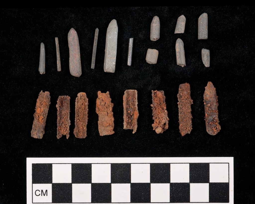
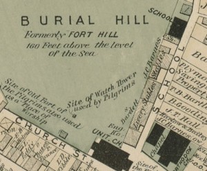
During the 2014 excavations on Burial Hill in Plymouth, one of the units was placed near the former location of a school, constructed in 1827. Beneath a dense deposit of brick rubble, we found many school-related small finds including 32 slate pencil fragments, 4 pencil leads, 18 pen nibs, 6 slate fragments, a piece of an ink bottle, and a copper alloy fragments that has been interpreted as part of a compass. Other artifacts in the deposit were also small (beads, pins, a hook and eye, rodent bones), suggesting that this was material that had fallen through the gaps between the floor boards.

Other small items from the same deposit, including the possible compass fragment, bottom row, 3rd group from the left.
The school lot was acquired by the Committee of the Center School District in 1826 (PCRD 156: 288). Davis writes that the school was constructed in 1827, the year after the purchase, and sometimes called the “town school” (Davis 1899: 286). Davis recalls, in his memoirs:
A school called the town school, was kept in my day by Thomas Drew in a house built in 1827, which has been recently taken down. It stood also on School street, near the way up Burial Hill, a little distance south of the high school house. The boys attending that school were older and larger than the high school boys (Davis 1906:343).
Historic maps of the later 19th-century indicate some variability in the building’s function. Though 1874 and 1896 maps clearly label this building as a school, 1885 and 1891 maps label it as storage. This could have meant that the school was only taught part time, which is not uncommon for the time period, or that its school function was over, but the building was known by its former use. By 1901, the school building, as well as the other non-residential buildings along School Street, had been demolished.
Discussion of the possible compass fragment

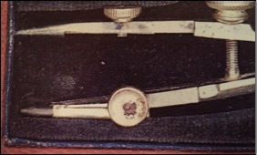
Detail of a compass pencil holder, showing a parallel for the piece recovered archaeologically. Photograph from Hambly 1988.
The first bow compasses got their name from the bow-shaped spring mechanism joining the two compass legs. These started appearing in drafting sets by 1650. Advancements in metal alloy production in the 18th century led to production of compasses in brass and sterling silver. During this early period, German manufacturers predominated, though major European cities such as London and Paris had their own accomplished instrument-making tradesmen (Hambly 1988:20-23). British manufacturers in the 18th century were the first to include pencil inserts for cedar-encased graphite rods in their bow compasses (Hambly 1988:66).
With the Industrial Revolution came the growth of mass production of these kinds of instruments, and in 1850, German manufacturers introduced a new alloy: German or ‘nickel’ silver. Also commonly called electrum due to its similarity in appearance to the Roman metal of the same name, this alloy of zinc, copper, and nickel was non-corrosive and more durable than both brass and sterling silver. Though skilled tradesmen were still needed to assemble the various parts of compasses, most of the manufacturing by the middle of the 19th century was handled by machines. By 1888, craftsmen were producing instruments more cheaply for use by students and professional surveyors. Also around this time, European immigrants to America began setting up their own instrument-making enterprises, first in Philadelphia, and later in New York, Chicago, St. Louis, and San Francisco. By 1900, American consumers were no longer relying on imports from London to sustain their growing need for scientific and mathematical instruments. William Kueffel, Hermann Esser, and Theo Altender – all prominent makers of scientific instruments in the 19th and 20th centuries – saw their business grow during this time period (Hambly 1988:28-30). A 1912 Sears and Roebuck catalog lists a drawing compass for sale:
Compass and Divider. Reliable in its work, useful for school children, artists, draftsmen, etc. Nickel plated, regulated by spring and screw adjustment, in boz. [sic] with nickel box containing six extra leads. Price … (Postage extra, 4 cents) … 16c. (Sears, Roebuck, & Co. 1912:956).
Comparative collections from other 19th century schools
As part of the research on this deposit, we surveyed the literature on other school sites in the northeast. Extensive work has been done on the Abiel Smith School, a mid-to-late 19th-century free public school for African-American children on Beacon Hill in Boston (Mead 1995; Pendery and Mead 1999; Landon 2007). These excavations have rightly focused on the School’s role as an important institution in the African-American community. These excavations uncovered numerous slate pencils and probable writing slate fragments. Excavations at another school on Beacon Hill – the early-20th century Peter Faneuil School – focused on deposits pre-dating the schools construction (Clayton et al. 1993).
UMass Amherst conducted field excavations on a site associated with a number of buildings, including a late-18th century schoolhouse in Deerfield, Massachusetts (Rotman et al. 2001). Excavations did not recover any intact features relating to the schoolhouse, though several slate pencils were recovered (Rotman et al. 2001:19). Researchers from the same University were more successful in their excavations of the schoolyard of a still-standing 1840 schoolhouse in Hadley, Massachusetts (Donta 1998). Archaeologists found 41 school-related items from 17 STPs: 30 slate fragments, 5 pieces of chalk, three slate pencil fragments, two pen nibs, and one thumb tack, accounting for 8% of the total artifact assemblage (Donta 1998:15). No mention is made of any copper-alloy artifacts that could potentially be school instruments.
Several excavations conducted by the Delaware Department of Transportation have recovered artifacts relating to public schools across the state (Catts et al. 1983; Bowers 1986; Catts et al. 1986; Walker 2009). Ranging from 1820 to 1920, artifacts recovered from the schools researched as part of these projects have included clay marbles, slate pencils and flat slate fragments, chalk, toys, an inkwell, a porcelain horse’s head figurine fragment, and a doll’s cup fragment.
Schools represent a unique opportunity to see how childhood was constructed materially in a setting where children were being enculturated to become productive adult members of society, yet school deposits are not generally studied through the lens of the archaeology of childhood. What items they had with them during the school day could tell archaeologists a great deal about what these children valued and how they mitigated the very rigorous structure of school life.
References
Bowers, Martha H.
1986 Architectural Investigations of the Route 7 North Corridor, Milltown of the Pennsylvania State Line, New Castle County, Delaware . In Archaeological Series No. 48, pp. 131-148. Delaware Department of Transportation, Dover, DE.
Catts, Wade P., Kevin W. Cunningham and Jay F. Custer
1983 Archaeological Investigation at the Welsh Tract School District No. 54, Newark, New Castle County, Delaware. Delaware Department of Transportation Archaeological Series No. 60. Dover, DE.
Catts, Wade P., Mark Shaffer, and Jay F. Custer
1986 Phase I & II Archaeological Investigations of the Route 7 North Corridor, Milltown to the Pennsylvania State Line, New Castle County, Delaware. In Archaeological Series No. 47, pp. 32-134. Delaware Department of Transportation, Dover, DE.
Clayton, David E., Ricardo J. Elia, and Nancy S. Seasholes
1993 Archaeological Investigations at the Peter Faneuil School Site on Beacon Hill in Boston, Massachusetts. Report of Investigations No. 113. Office of Public Archaeology, Boston University, Boston, MA.
Davis, William T.
1906 Plymouth Memories of an Octogenarian. Bittinger Brothers, Plymouth, MA.
1899 Ancient Landmarks of Plymouth, 2nd edition. A. Willliams and Company, Boston, MA.
Donta, Christopher
1998 Archaeological Intensive (Locational) Survey for the Proposed Hockanum School Stabilization Project, Hadley, Massachusetts. UMass Archaeological Services, Amherst, MA.
Hambly, Maya
1988 Drawing Instruments: 1580-1980. Sotheby’s Publications, New York, NY.
Landon, David B., ed.
2007 Investigating the Heart of a Community: Archaeological Excavations at the African Meeting House, Boston, Massachusetts. Cultural Resource Management Study No. 22. Andrew Fiske Memorial Center for Archaeological Research, University of Massachusetts Boston, Boston, MA.
Mead, Leslie A.
1995 Intensive Archaeological Survey at the Abiel Smith School House At Boston African American National Historic Site, Boston, Massachusetts Archaeology Branch, Cultural Resources Center, National Park Service, 400 Foot of John Street, Lowell, MA.
Pendery, Steve, and Leslie Mead
1999 Archaeological Investigations at the Boston African American National Historic Site, Boston Massachusetts. Archaeology Branch, Northeast Cultural Resource Center, Boston System Support Office, National Park Service, Lowell, Massachusetts.
Rotman, Deborah, Robert Paynter, Christopher Null, and Kai Heidemann
2001 Report of the 2000 University of Massachusetts, Amherst Field School Study of Lot 33 in Deerfield, Massachusetts. Department of Anthropology, University of Massachusetts Amherst, Amherst, MA.
Sears, Roebuck, and Company
1912 Catalog No. 124. Sears, Roebuck & Co., Chicago, IL.
Walker, Joan M.
2009 A Phase I and II Survey of Lancaster Pike (Route 48) from Newport Gap Pike (Route 41) to Centre Road (Route 141) and Phase III Investigations of the Oak Hill Schoolhouse, New Castle County, Delaware. Delaware Department of Transportation, Dover, DE.


