As we honor and celebrate Juneteenth, the New England African American Archaeology Lab is proud to share its recently completed ArcGIS Story Map. Juneteenth, a celebration of African American freedom, education, and achievement, is the perfect backdrop for this Story Map. It shares the history of Nantucket’s 18th and 19th-century community of color, New Guinea, and celebrates ten years of NEAAAL’s influential research under the guidance of Dr. Nedra Lee. This Story Map is a testament to Black persistence and resistance. Join us in this celebration by viewing the Story Map!
Archaeologists from UMass Boston will hold a public outreach event on Tuesday, June 11 at the John Jermain Memorial Library in Sag Harbor, NY, from 12:30-2:30 PM to discuss the upcoming GPR survey of the Afro-Indigenous Burial Ground at Sylvester Manor. Dr. John Steinberg will lead the survey and will join Drs Nedra Lee and Stephen Mrozowski to discuss the ongoing historical research and survey scheduled for this Fall. The Sylvester Manor Archaeological Project team looks forward to discussing the historic and sacred significance with contemporary communities as we continue to understand the Afro-Indigenous Burial Ground for further memorialization of the site. See you all on Tuesday, June 11!
Students and staff from the Fiske Center for Archaeological Research at the University of Massachusetts Boston have recently completed a joint project with the Collections Department at Plimoth Patuxet Museums, funded by the Humanities Collections and Reference Resources program at the National Endowment for the Humanities. This grant created digital catalog records for over 75,000 archaeological objects, now accessible through the Museums’ online collections portal.
The NEH grant, “Digitizing Plimoth Plantation’s 17th-Century Archaeological Collections,” provided the funding for a joint project between the Museum and the Fiske Center to work on four of the Museums’ collections:
The Winslow site, home of colonial governor Josiah Winslow in the late 17th century (excavated primarily in the 1940s);
The Allerton-Cushman site, home of Mayflower passenger Isaac Allerton in the 1630s and later his son-in-law Thomas Cushman in the 1650s and later decades (excavated by Deetz in 1972);
The Bradford II site (excavated by Deetz in 1966); and
The RM site, home of the Faunce family in mid to late 17th century. Initial processing for the RM site had been done under an earlier pilot grant (from UMass Boston), but the digital access to information about this site and collection was facilitated under the NEH grant.
These four collections were selected because of their research potential, their potential to shape public interpretation at Plimoth Patuxet, and their importance to the history of the development of the museum and historical archaeology, particularly through the work of Henry Hornblower and James Deetz.
Plimoth Patuxet Museums (formerly Plimoth Plantation), in Plymouth, Massachusetts, is best known for its living history exhibits of Wampanoag and 17th-century New England history, but also curates over 50 archaeological collections from the region. Some of these were excavated by the museum’s founder Henry Hornblower in the 1940s; other collections were excavated by James Deetz, a central figure in the development of the discipline of historical archaeology, in the 1960s and 1970s. These collections, which span periods from the deep Indigenous past through the mid-19th century are an important source of information about the lives of the people who lived in Massachusetts. Prior to the start of this grant project, these collections remained in storage, relatively unexamined since their initial processing and research. As the collections were not publicly available online or presented as part of the visitor experience, the only people who knew of their existence were those who worked in the Museum’s Collections Department, or individuals who learned about them through word of mouth. This made it difficult for staff, students, Indigenous communities, and researchers to access these collections. This was further compounded by the fact that some of the collections were relatively untouched since the early 1980s. The collections catalogs ranged from Excel files, to typed manuscripts from the mid-20th century, to print outs of coded information from legacy database formats.
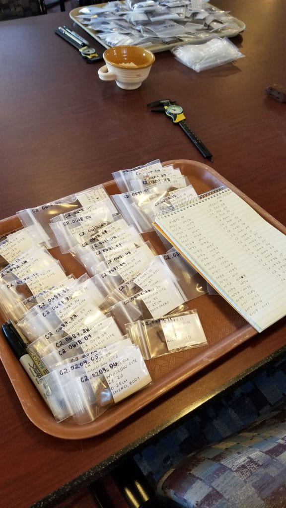
Under the grant, the Museum developed and implemented its first uniform system for processing its archaeological collections. This includes creating digital catalog records in a Past Perfect database; taking digital photograph of each object; rehousing objects in archivally stable storage bags and boxes; capturing provenience information that was in danger of being lost; re-organizing the archaeological collections by provenience so that objects can be easily found for study or exhibit; sharing the digital catalog through an on-line collections portal; and creating site specific web pages with a summary for the general public and links to finding aids and in-depth collections information for scholars.
This process developed with NEH funding is now being applied to additional archaeological collections at the Museum. The development of the Past Perfect database, with both an internal interface for collections management (with information such as conservation status, storage location, and loan status) and a public-facing interface with a simplified view of the database that is linked on the Museum’s website, has been particularly important to the Museum, both for managing its archaeological collections and for improving how collections are presented online.
Site Specific Results
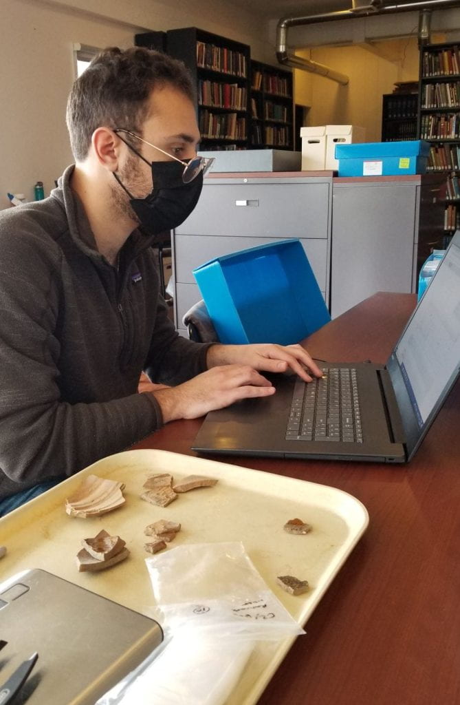
Almost 19,000 digital catalog records and photographs have been created in Past Perfect under this project, describing 75,512 objects related to this grant (20,348 from the RM site; 26,692 from the Winslow site; 3472 from the Bradford site; and 25,000 from the Allerton-Cushman site). This represents the entirety of the RM, Winslow, and Allerton-Cushman collections. The grant work revealed that the Bradford collection came primarily from the mid-19th century and did not have a significant 17th-century component, so it was only partially cataloged. This new information about the Bradford collection is in itself important, correcting long-held beliefs about the date of the site. Re-examination of the collections also prompted additional research into the RM site by the Museum that found past interpretations about who lived there were not correct.
The RM site (C1; Massachusetts Historical Commission Site #PLY.HA.7) is a mid- to late-17th century fortified dwelling house likely lived in by the Faunce family. It is called the RM Site because of a spoon found there with the letters “RM” etched onto the handle, possibly associated with Thomas Faunce’s cousin Remember Morton. Spatially and geographically, it is closely connected to the nearby Eel River Wampanoag site. The majority of the RM collection is 17th- and 18th-century colonial artifacts, with a smaller, but sizable, component of Indigenous artifacts, and some unique early contact-era trade goods. The site also contains many goods of a military nature, such as lead shot, gun parts, and gunflints, along with typical early colonial domestic goods, such as pipe stems and ceramics.
The Winslow Site (C2; Massachusetts Historical Commission Site #MRS.HA.2), located in Marshfield, MA, was the home of Josiah Winslow (son of Edward Winslow) and his wife, Penelope Winslow (née Pelham). Josiah Winslow was the first Plymouth-born governor of the colony, who held office between 1673 to 1680. His probate records indicate that he had a wealthy household: a two story structure with a substantial dairying component with cattle and milk pans. The artifact assemblage reflects the household’s wealth and indicates that the site was occupied in the latter half of the 17th century. The site has a much more substantial collection of stone tools than was previously recognized, as well as a wide range of metal tools, animal shoes, and horse harness components.
The Allerton-Cushman Site (C21; Massachusetts Historical Commission Site #KIN.HA.19) was excavated by James Deetz in 1972 as part of a rescue effort before the construction of a house on the residents’ property in Kingston, MA. Deed research associated the site with Isaac Allerton, a Mayflower passenger, and subsequent generations of his family. The archaeological survey revealed a post-in-ground constructed house dating to c. 1630 to 1650. The house measured 20 by 22 feet, was supported by four large, square timber posts, and enclosed with wattle and daub walls. The Allerton-Cushman site presented the first physical evidence for post-in-ground construction in Plymouth County and influenced the way reproduction colonial houses were built in the English Village at Plimoth Patuxet Museums.
Broader Significance
The Winslow site, the Allerton-Cushman site, and the RM site date to the 80 years following the English colonization of Massachusetts. This was a transformative time period, both for the newly arrived colonists and the Wampanoag and neighboring Indigenous communities. Archaeologists and museum educators are using these older “legacy” collections to ask new questions about colonization and life during this period. In particular, these collections contain many more Indigenous artifacts than previously known, allowing for a more complex interpretation of the interaction between the Wampanoag and the English colonists, and allowing for the study of the continued presence of Wampanoag individuals in the 17th century at sites that have previously been considered exclusively English.
Creating accessible digital information about these artifacts has also enabled their incorporation into educational resources for a wide range of audiences. Beyond their use by scholars of the region’s history and archaeology, the Museum has incorporated archaeological artifacts in online games from children and in teacher training workshops that they have held over the past several summers. The COVID pandemic accelerated the need for digitally-available content from cultural organizations everywhere. The grant work, which began in 2018, was thus very timely and enabled the Museum to more quickly develop and deploy digital exhibits and educational material.
The grant has prompted the Museum to re-think how its archaeological collections are presented online. Previously, no information about the archaeological collections was available on the Museum’s website. Scholars, the public, and Tribal communities had no clear way to learn about the collections held at the Museum. Now, in addition to an online collections portal, the Museum is developing an online exhibit and web sites related to the collections covered in this grant. The digital exhibit will share the knowledge about these collections acquired through this digitization project and incorporate photographs of the objects from the collections, field notes and illustrations from the Hornblower archives. To tie into the Museum’s 75th anniversary, the exhibit incorporates institutional history to tell the stories the role archaeology has played in its exhibits and mission over the decades using examples from the recently digitized collections. The web pages will describe the work at each site, highlight objects from the archaeological collection, and provide links to collections summaries and finding aids for scholars.
In April of 2022 the Fiske Center for Archaeological Research began an exciting project in Marblehead Massachusetts. The Marblehead Museum is interested in understanding the yard space around the Jeremiah Lee Mansion, a Georgian mansion built in 1768 for Jeremiah Lee, the wealthiest merchant in colonial Massachusetts at the time.
More specifically, the project seeks to investigate the space on the east side of the house, between the Mansion and the Brick Kitchen. This brick building dates to the same time period and may have housed the mansion’s enslaved residents or domestic servants. By investigating this lot, we are hoping to encounter older 18th century archaeological deposits, deposits from the Lee period, or deposits and foundations from later buildings that occupied this space.
In preparation for a ground penetrating radar survey in late April and excavations in June, the first step was to georeference all the old maps, which was described in a previous post. The next step is to create an orthophoto. This is an aerial image that has been geometrically corrected (ortho-rectified) so that the image has uniform distance measurements across the entire photo and is perfectly top down. Unrectified aerial or satellite images suffer from terrain effects and distortion from the camera lens and the angle that the photo was taken, which can cause problems in later processing steps. You can see these kinds of images on google earth- notice the sides of the buildings.
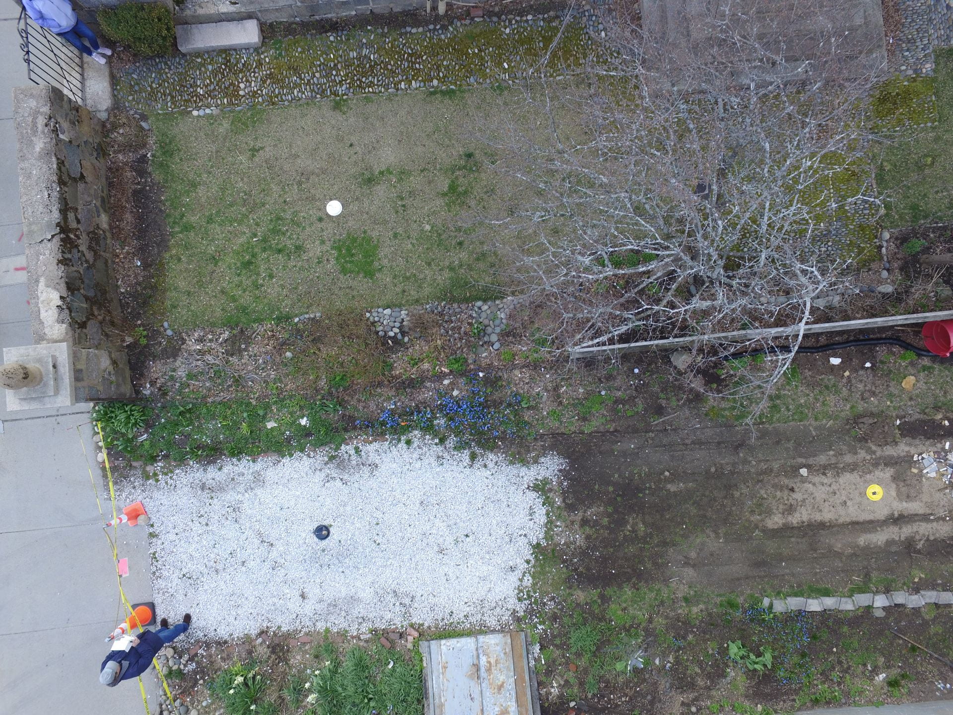
To create the orthophoto, ground control points were laid out across the site and a large number of drone photographs were taken.
Drone photo showing different color paper plates used as ground control points
Ground control points are places on the ground (in this case paper plates) with known coordinates associated with them. These points are used to tie map coordinates from the aerial photos to precise points on the earth, thereby yielding an accurate product. John Schoenfelder flew the drone and did much of the mapping.
John Schoenfelder flying drone in front of Lee mansion
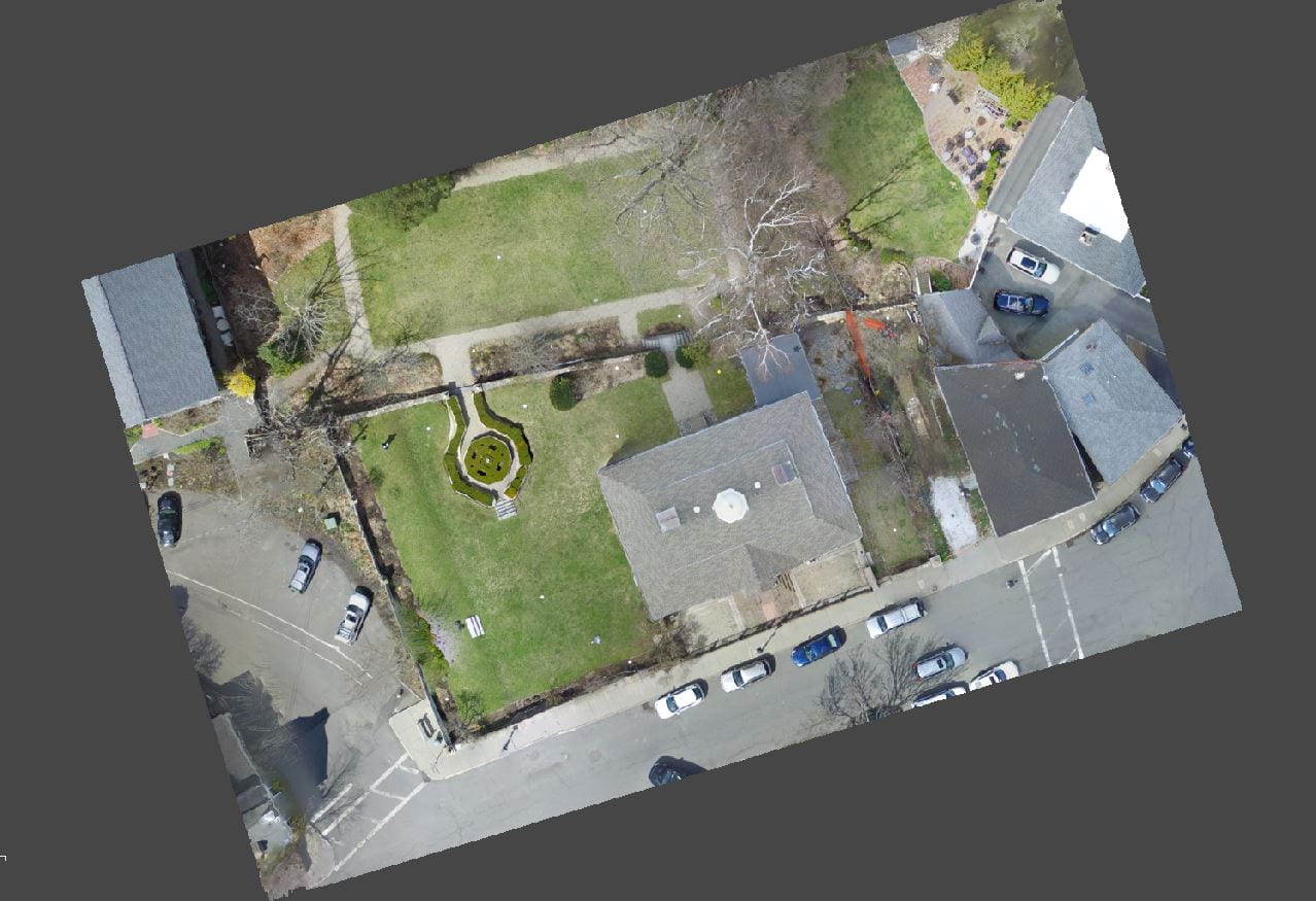
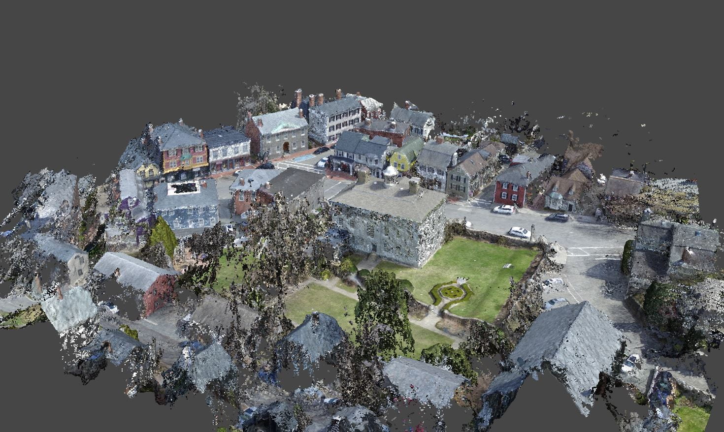
Using the photogrammetry software Agisoft Metashape, we created an orthophoto of the Lee Mansion grounds. This software requires you to build a “sparse cloud” and a “dense cloud”, which are used to generate the orthophoto.
Orthophoto of Jeremiah Lee Mansion. The photo is from a perfectly top-down orientation.
The sparse cloud generated in Agisoft Metashape
Dense cloud generated in Agisoft Metashape
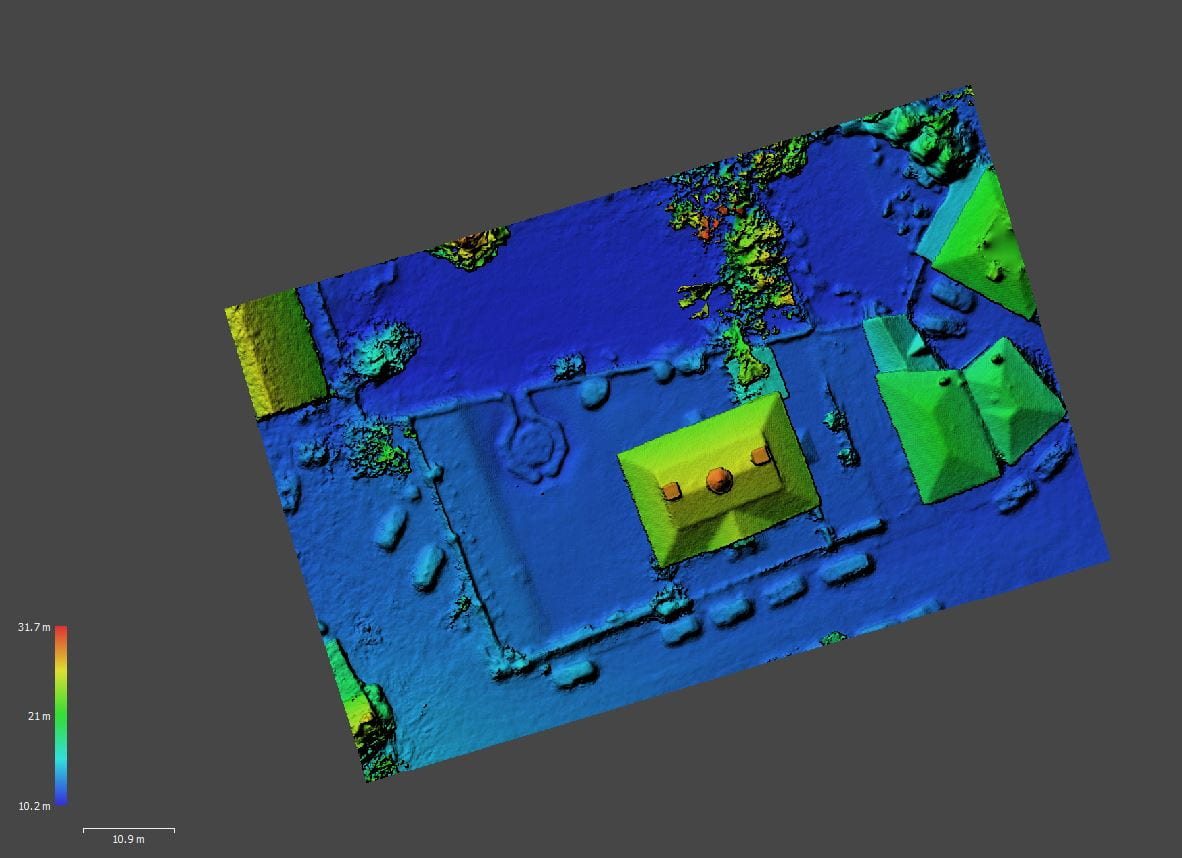
These are both types of point clouds that exist in three-dimensional space. The sparse cloud represents the tie points for overlapping image pairs while the dense cloud generates depth maps for these overlapping pairs and merges them together to create a three-dimensional model of the site. The dense cloud was used to create a digital elevation model of the site, which was then used to create the final orthophoto.
Digital elevation model created in Agisoft Metashape from the dense cloud
While not really needed for our work, a byproduct of the orthorectification process is that with just a few additional processing steps, we refined the three-dimensional model of the site and created a “fly-through” animation.
Fly-through animation of three-dimensional photogrammetry model
In May of last year (2021) the Marblehead Museum was able to reunite the whole of the Jeremiah Lee Property when the organization purchased the neighboring Brick Kitchen at 157 Washington St.
The first phases of that archaeological excavation at the combined Lee Mansion and Brick Kitchen have begun. In preparation for excavations in June of 2022, the staff and graduate students of the Fiske Center for Archaeological Research have been studying the site, georeferencing old maps, taking drone photos of the property, and conducting a series of geophysical surveys.
The Mansion and Brick Kitchen were constructed in 1766. Jeremiah Lee died in 1775, and his estate was eventually liquidated in 1788. His widow, Martha Swett Lee, may have continued to use the house after Lee’s death. The Lee property has been owned by the Museum since the early 20th century and served as the Marblehead Bank for most of the 19th century. Due to the long period of institutional use (with minimal construction, demolition, and utilities), there is a potential for well-preserved 18th-century deposits on the property.
Before we interpret the results of the geophysical surveys and plan excavations, we try to georeference every old map we can of the area in question. There is a wonderful series of georeferenced maps on the Marblehead Historical Commission’s website. The maps in this post have been georeferenced specifically for the Lee Mansion property. Below is a sample of some of the many maps that we looked at, to understand the complex history of the site.
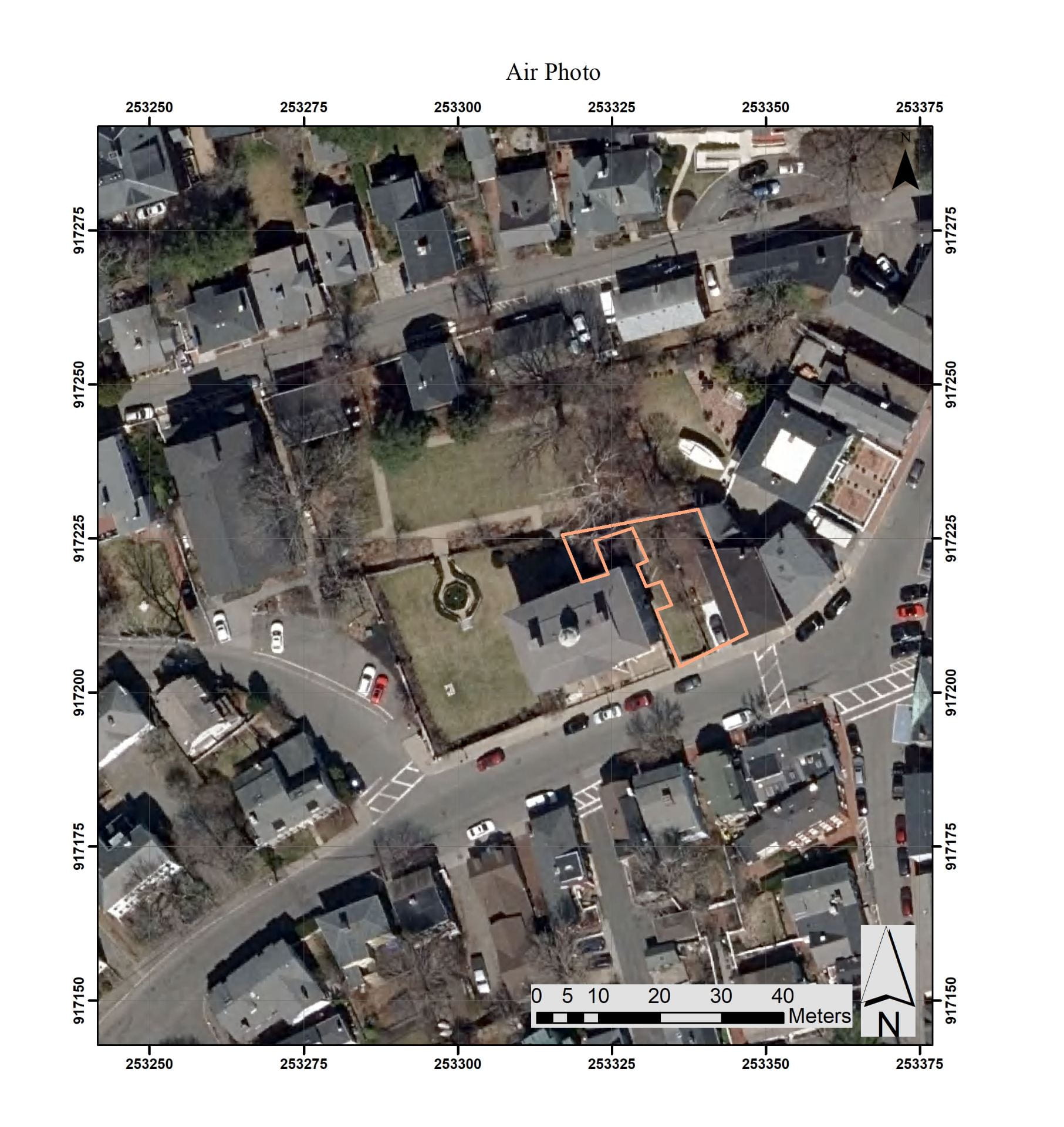
Air photo of area around Lee Mansion
The 2022 excavations will concentrate on the area between the Mansion and the Brick Kitchen. This area of investigation is highlighted in orange on this aerial photograph.
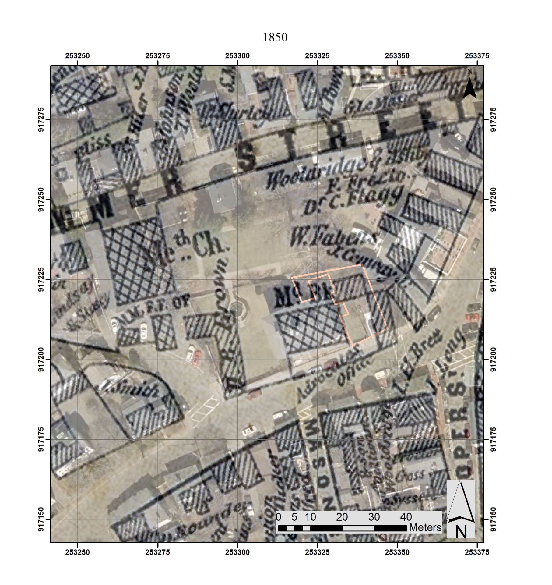
1850 Map of the area around Lee Mansion superimposed on air photo
While there are several earlier maps of Marblehead, the 1850 Henry McIntyre map is the first one with any details of the Lee Property. It shows the Mansion (labeled Md. Bk), the Brick Kitchen to the east, and an upside-down “L” structure to the west that is no longer standing. Behind and between the Mansion and the Brick Kitchen another structure is indicated.
1872 Map of the area around Lee Mansion superimposed on air photo
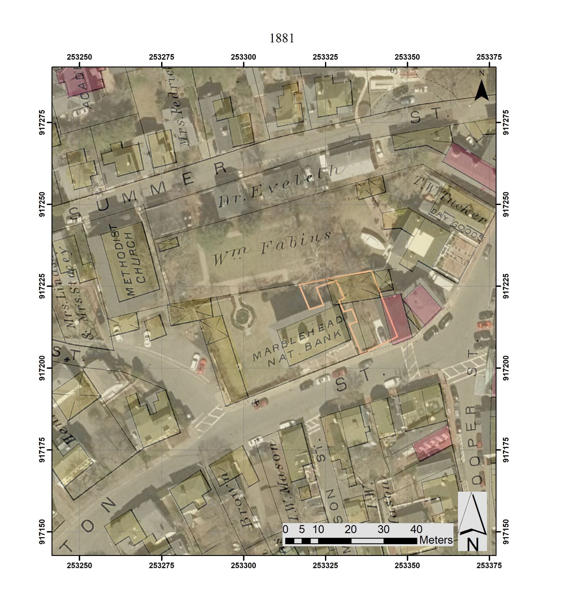
1881 Map of the area around Lee Mansion superimposed on air photo
The first really detailed map is from 1881, called the Atlas of Marblehead, published by Griffith Morgan Hopkins Jr. On this map, structures with an x through them are stables or sheds, and brick buildings are colored pink. Stables are indicated to the west of the Mansion and a large stable/shed is drawn at the end of the area between the Mansion and Brick Kitchen.
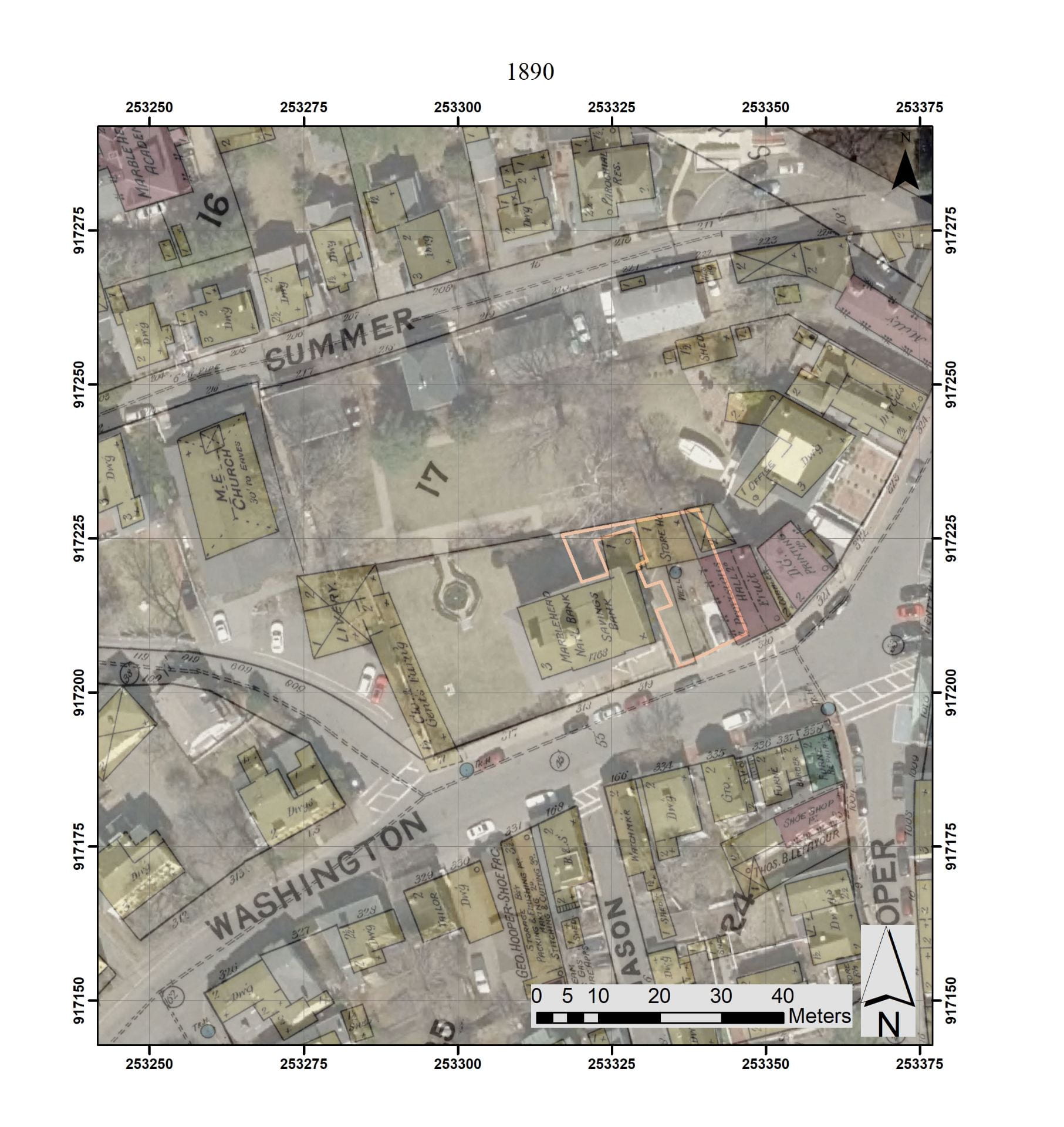
1890 Map of area around Lee Mansion superimposed on air photo
An 1890 map is an extremely detailed map of the area. It is also one of the famous Sanborn fire insurance maps. This map shows a blue dot indicating a well or well pump between the Mansion and Brick Kitchen. The image shows the northeast kitchen addition to the Mansion. The large shed drawn in the 1881 map (above) seems to have been replaced by a smaller storehouse. The structures to the west of the Mansion are still indicated.
These georeferenced maps are an important tool in understanding the development of the site and interpreting the geophysics and planning and interpreting the archaeological excavations
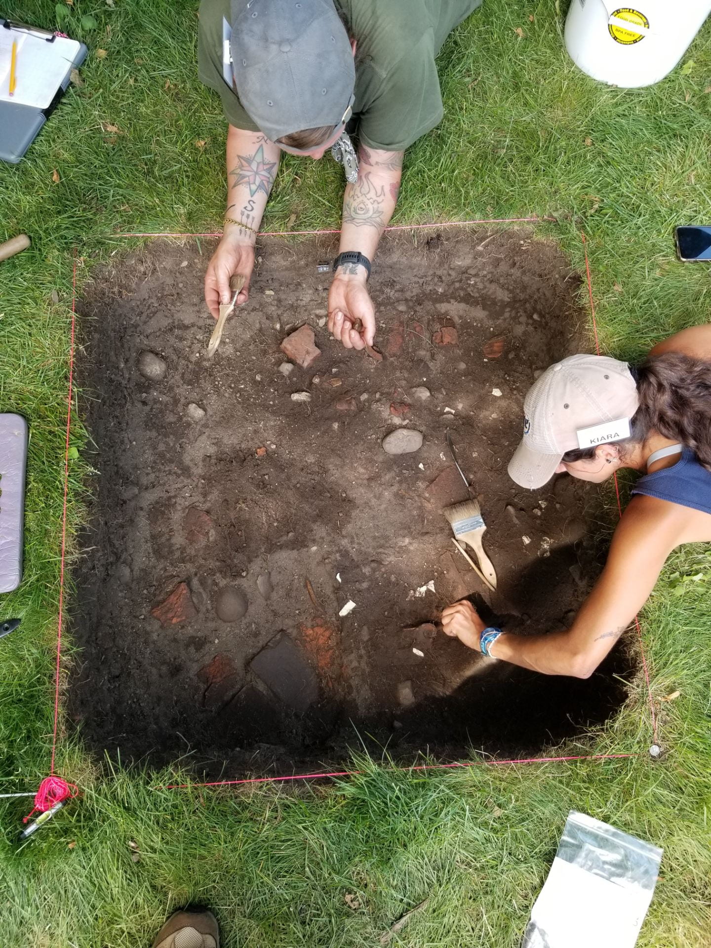
The UMass Boston field school is back in Plymouth this year, at two sites where we have worked before.
Nicholas and Kiara excavating a late 18th-century midden deposit in 2021.
One of these is a lot along Cole’s Hill that is owned by Pilgrim Hall Museum. Today, it is grassy and open, but in the early 1800s, it would have been divided into four different lots, with multiple houses and outbuildings. We excavated here in 2016 and are back this year to learn more about some of the significant deposits. Pilgrim Hall plans to landscape this parcel to visually connect it to the other memorials along Cole’s Hill, turning this space into a Remembrance Park honoring the Great Dying of 1616-1619 (an epidemic that affected the Wampanoag of Patuxet and other Native groups), the deaths of the Mayflower colonists in the winter of 1620-1621, and the 2020 pandemic.
Before they do that work, our archaeological excavations will gather more data about a few areas of the property, particularly the two older houses; one was owned by a series of mariners and the other was the first residence of the Jackson family on this lot. Previous excavations learned a lot about the 19th-century residents; this season is targeting information about the 18th-century households. We are also following up on excavations done by UMass Amherst in the 1990s that identified a small area where parts of a much older Native site were preserved despite all of the later building activity. We have three excavation areas open now, with a fourth planned.
An 1882 sketch of Cole’s Hill showing the 19th-century duplex on the lot. Several 18th-century houses had existed on this lot previously.
You can visit the site during the week; docents from Pilgrim Hall Museum and Plymouth 400 are available to talk about the work and the plans for the park between 10 and 3. The Associated Press story about the work, with some photographs of the excavations in progress can be found here.
Kati Albert ’21 is a recent graduate of the Historical Archaeology Master’s program, and this year’s recipient of the Chair’s Award in Leadership and Service.
Since joining the UMass Boston Historical Archaeology Master’s program in 2018, I have been so grateful for the support and opportunities this program has offered me, including the connections I have made with the UMB Alumni network, and the organizations and resources I have learned about over the last few years. To help current and future students (and recent alumni), I have created a guide to finding employment in archaeology or closely-related fields: a compilation of the knowledge that has been passed down to me, as well as research I have done on my own. It is primarily focused on the Boston-area and greater northeast, but I hope that students who come after me will find it useful when thinking about their short and long-term career plans in archaeology.
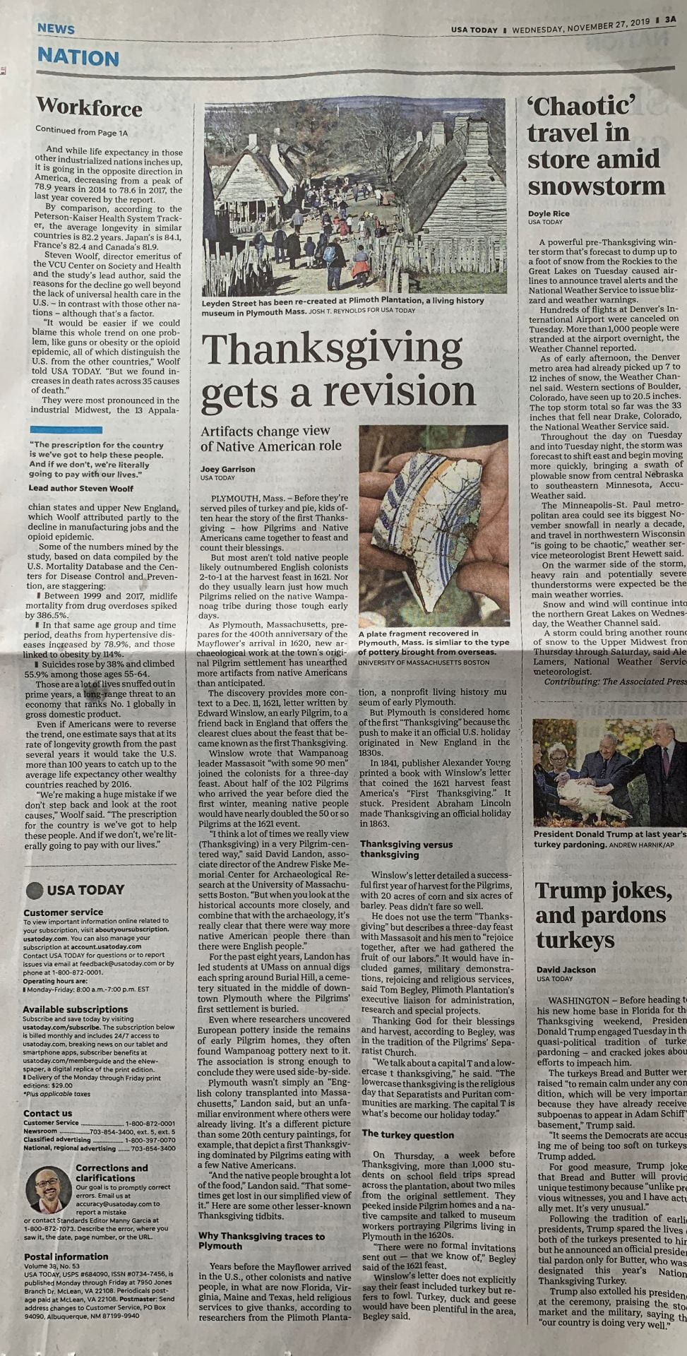
Over the Thanksgiving holiday, Joey Garrison of the USA Today had an article that featured some of the results of the UMass Boston excavation at Old Burial hill. The online version can be found at :
Happy October and happy Massachusetts Archaeology Month to all who follow the Fiske Center and UMB Archaeology!
To speak very personally, I love archaeology month. I see it not just an opportunity for us to pat ourselves on the back and celebrate the great work that we do, but also as a time to reach out to the public and show a larger audience what it is that we do, and why it is so interesting. Connecting to the public is such a powerful thing for archaeologists; there is a lot that both groups can offer each other if they take the time. As such, this Archaeology Month is as much a time for sharing with others as it is for highlighting our efforts for our colleagues and ourselves.
It’s been a great month for us at the Fiske Center/UMB so far both in terms of our field projects (a geophysical survey at Gore Place in Waltham, MA, and an STP survey in Pembroke, MA), as well as our special outreach events.
The month began with members of UMB’s Society for Graduate Archaeologists (SGA) tabling in the university Campus Center. Armed with books, archaeo-botanical samples, a video of students in the field (check that out here: https://www.youtube.com/watch?v=dDYqxhXCKX0&feature=youtu.be ), and an artifact guessing game, the SGA worked to spread the word about the archaeology at UMB from the research projects, to the master’s program, and the opportunities to volunteer. It was a great opportunity to share our work with the larger student body, and to touch base with people interesting in learning more about our work, or becoming involved with us.
SGA members tabling for Archaeology Month
The SGA will be back tabling next week on Monday the 28th and Wednesday the 30th. Feel free to stop by, say “hi”, and learn about the amazing archaeological experiences UMB has to offer.
Students have also given talks relevant to their theses this month as well. On October 10th, current 3rd year Elizabeth Tarulis gave a presentation about her thesis research at the Alden House Barn. She discussed the larger connections and trade networks behind some of the ceramics from the Alden collection and the vessels that have been recovered during the excavations at Burial Hill during the Plymouth Field School.
Alden Talk Poster featuring Elizabeth Tarulis’ thesis presentation
This past weekend, current graduate students Lissa Herzing and Jared Muehlbauer working on the Boston-Higginbotham House collections gave a presentation to the Nantucket on the excavations conducted there in 2014 and the subsequent research that has been conducted. They shared some of their analysis on the rich collections of artifacts recovered from the excavations, which shed more light on the diverse people from the island’s history.
Even though we’ve done a lot already, we still more archaeology events planned for October! Coming up on October 30th, associate director of the Fiske Center, Dr. David Landon, will be presenting at Pilgrim Hall Museum on the excavations that have been conducted in downtown Plymouth over the past several years. This will be an opportunity to learn about the most recent excavations and discoveries from Burial Hill, where part of a 17th-century structure has recently been found.
For more information about up-coming events happening all across Massachusetts, please visit the Massachusetts Archaeology Month page on the Massachusetts Historical Commission’s website at: https://www.sec.state.ma.us/mhc/mhcarch/arch_month/archidx.htm
The Fiske Center for Archaeological Research is about to start a project at the Turner House in Pembroke, MA. We’ll be doing a shovel test pit (STP) survey, which is often the first phase of excavation at a site. This post will explain what an STP survey is and talk about some of the questions we’d like to answer. As the project goes on, we’ll be doing short Facebook (at the Fiske Center) and Instagram (at UMBArchaeology) updates for those who’d like to follow along!
The Turner house in Pembroke, summer 2019
But first, a little about the Turner House –
The Turner House and the land around it are owned by the Town of Pembroke. The Turner family purchased the land in the 1600s, and John Turner was an important local figure in the political activity leading up to the American Revolution. The standing house dates to the early 19th century and was probably built when John Turner’s son or grand-nephew owned the land. Members of the Pembroke Historical Commission wanted to learn more about the property around the house, so contacted the Fiske Center to conduct some research. We’d like to find out if there any places where there are archaeological deposits that could tell us more about the people who lived here, either in this house, in older houses on the property, or before the colonial period. There haven’t been many archaeological digs in Pembroke focused on historic sites, so we’re excited to see what we learn.
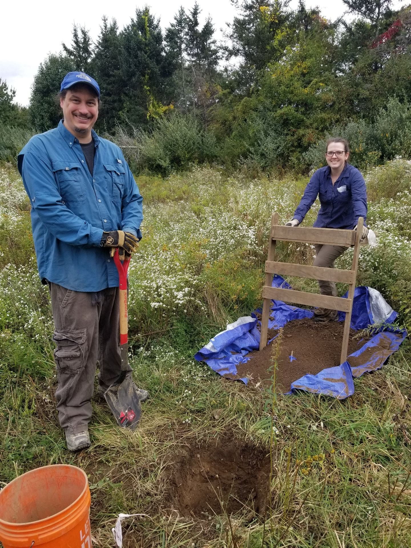
UMass grad students Rick and Megan with an STP at the Turner House
One of the questions that people always ask archaeologists is how we decide where to dig. A shovel test pit survey is one of the ways to answer that question. During an STP survey, we dig small excavation units at regular intervals across the landscape, every 15 feet for example. We use these to look for artifact concentrations, or places where older soil layers are present, buried under the modern surface. Lots of shovel test pits might have nothing in them, but a concentration of test pits with bricks and nails might help us narrow down where an old building stood. Broken bits of dishes and other household artifacts could tell us where people threw out their trash at different periods in the past. Since we know the date ranges of many kinds of artifacts, trash from different time periods can tell us when people used different parts of the landscape, from the ancient Native past to much more recent times.
We are planning a shovel test pit survey at the Turner House, small 50 x 50 cm (1.5 x 1.5 ft) excavations spaced out over part of the property. We have some specific questions that we hope to answer this fall using this method.
First, what have been the effects of more recent activities on archaeological deposits? Anything from plowing a field to installing a utility pipe can affect things that are buried. How well preserved are the areas around the Turner House?
Second, if the existing house dates to the early 19th century, where were the Turners living for the century before that? There was an older house on the property — can we find evidence of it? Or was it under the standing house?
Finally, what about the Native past? Are there places where the evidence of how Native people used this land are still preserved after centuries of plowing and building? It might surprise you how often this kind of evidence survives, even in much more heavily developed areas.
We’ll be trying to answer these questions and more this fall. Feel free to ask questions here or on Facebook. We’d especially love to hear from you if you know about historic maps, photos, or drawings of the Turner House!