SASS – UMass Boston – Fiske Center – Archaeology

Blog of the Skagafjordur Archaeological Settlement Survey

July 13, 2009
by Laura Ng
0 comments

Finding Boundaries in Seyla

At Seyla, we have continued looking for the boundaries of the cow barn and the walls of the skali (longhouse). We have been troweling through deposits of collapsed turf and tephra (ash from a volcanic eruption) and have occasionally come across animal bones. Mike Way and Kate Johnson have been excavating a peat ash and burn deposit.

As mentioned in the previous post, an area of Seyla was deturfed and imaged using GPR. Below is a picture of Mike, Marisa, and Brian using the machine to conduct GPR.

July 10, 2009
by Christa Beranek
0 comments

Expanding at Seyla

Today we had a backhoe to the site to uncover an adjacent 10 m swath so that Brian could run the GRP over it.  He had picked up the signature of half of a building and wanted to expand to see the whole building, possibly an early church.  Here’s a site overview with the newly exposed area at the right.

July 9, 2009
by Kathryn Catlin
0 comments

The Coring Team Takes a Field Trip

The coring team has been hard at work for the past few days!  We finished taking soil cores all over Pafastaðir, and today we began work on a farm mound at Kjartansstaðir.  We’ve been tiptoeing through the þufurs and wrestling with extreme dandelions.  On Monday we took a hike through field, bog, and stream to take a look at the tephra sequence on the abandoned farm at Melkot.

After a week I’m really starting to get hang of intepreting soil cores!


Fording a stream at Melkot


Beautiful tephra sequence at Melkot


John really gets into tephra.

July 9, 2009
by Christa Beranek
1 Comment

Chasing Walls

 While some folks are working on buildings and features that had been identified in previous seasons at Seyla, a few of us have been chasing out new turf walls.  For three days we’ve been following a long (15 meters) turf wall, either of a longhouse or some sort of enclosure.  We are just now starting to clarify what is happening at one end , but it’s still puzzling.  Meanwhile, at the end of the day today we uncovered more (possibly unrelated) bits of wall in the area we’ve been clearing, running in different directions.  All the walls and the fallen turf around them are covered by the bright white tephra of an 1104 eruption.  More updates if and when we figure out what these walls are doing.

Also at Seyla, Kate and Mike have been excavating a large fire-related pit that has produced a few interesting artifacts, a lot of bone, and some slag.

CMB
 

July 5, 2009
by Laura Ng
1 Comment

Link to Interactive Photo of Stora Seyla

An exciting and amazing composite photo of the site Stora Seyla has been created using a program called Microsoft Photosynth (http://photosynth.net/).

111 photographs of Stora Seyla that were taken on July 1 and July 2 using the kite and pole were stitched together to create a composite photo called a "synth." You can view the synth of Stora Seyla here.

After clicking the link and downloading SilverLight, you can scroll over the synth and click on any area within a white outline to zoom in on a specific photo.

LWN

July 5, 2009
by Kathryn Catlin
2 Comments

Aerial photography at Stora Seyla

Here are some of the aerial photos from Seyla.  The first two were taken with a camera on a pole on July 2: 

Kate and Laura working, while Pete holds the pole.

Kate looks up as Kelly wanders through.


This is a test image from the kite on July 1.  At the top are the group flying the kite and and the GPR team, people clearing the site in the middle, and at the bottom you can see the stone lines of the building we’re excavating.

Last night after our Fourth of July dinner (hot dogs, hamburgers, and french fries – it was delicious) we took a group photo:

The 2009 SASS team in Iceland.

July 3, 2009
by Kathryn Catlin
0 comments

Coring, Cows, and Kites

 For the last three days a group of us has been out taking soil cores at Jaðar and Pafastaðir, a small farm and a large farm north of Stora Seyla.  Here’s John checking out a core at Jaðar:

I’ve mostly been out with the GPS, making sure that we accurately record the locations of all cores so we can analyze them later with GIS software:

At Jaðar, we made friends with a wonderful little boy and his dog.  We took about a hundred core samples, and found, by sheer luck, the smallest midden ever.  Check out this profile:

And at Pafastaðir, just to round things out, we found the largest midden ever!  Today we did a lot of coring in the fields at Pafastaðir, among the þufurs – and in the cow pasture:

Orange flag, or delicious new flower?

Over at Seyla, there have been a few artifact finds (which I’ll let someone talk about who’s actually been working there), the site has been completely recorded with ground-penetrating radar, and they’ve been trying out some kite arial photography:

July 2, 2009
by Laura Ng
0 comments

GPR and Excavations at Stora Seyla

Greetings from Iceland! My name is Laura Ng, I am an incoming graduate student at UMass Boston and I will aso be writing some of the blog entries. Please bare with us while we continue to add to and update this blog.

At Stora Seyla we have been doing a few things, one of them being GPR (Ground Penetrating Radar). Brian, Kelly, and Rosie have been using a box-like machine to do GPR. The box is dragged back and forth across the site many times in order to get the best image of what is below the ground.

 Another crew has been working on removing and uncovering last year’s backdirt with shovels. As you can see, some areas have been uncovered and we have started excavating where last year’s crew left off.

June 30, 2009
by Kathryn Catlin
0 comments

Excavations – Day 1 (June 29, 2009)

Hi!  I’m Katy, an incoming graduate student at UMass Boston.  I’ll be writing some blog posts while we’re in Iceland this summer!

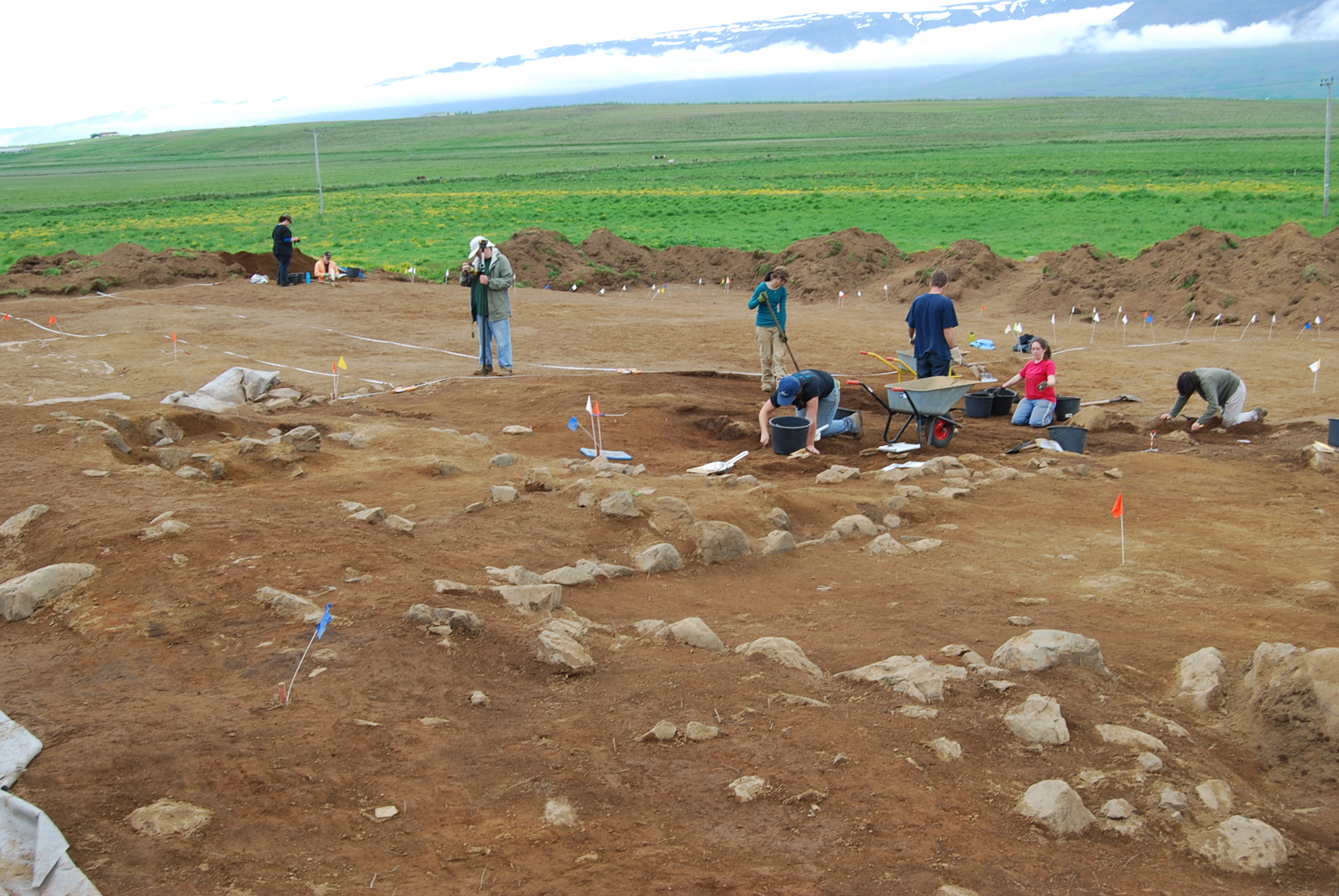
Today we were at Stóra-Seyla, a Viking-era farmstead a few miles outside of Sauðárkrókur.  SASS has worked it for several years in a row, so the site was under a layer of "geotextile," which was under a thick layer of turf.  Also, we want to do ground-penetrating radar on another part of the site, so another huge area needed to be cleared of turf and smoothed before we can start that.

Here’s what the site looked like when we got there:

We spent two hours busting sod and shoveling it off the cloth; then we had a coffee break, and then spent two more hours shoveling.  I took some pictures:


The horses were fighting at various points throughout the day.


These guys were out matching the site with data from last year, and planting flags to mark the boundaries.

Then we had a lunch break, and the backhoe finally showed up!
 

But then we still had to spend three more hours shoveling off the parts too delicate for the backhoe.  The backhoe mostly cleared off the area intended for GPR and moved away our dirt piles that resulted from shoveling.

Then we had another coffee break, and then we spent the last couple of hours shovel-scraping half the GPR area so the machine will be able to move over it smoothly.

We did run into a tephra layer while shovel scraping, and we also encountered a couple of pieces of historic (19-20th c) ceramic pieces, which we will track store separately from the Viking-era artifacts we should be finding later.

And this is what it looked like after we left:

The part we did by hand is the lighter-colored stuff in the front.  The backhoe did the rest.  The part on the left that looks smoother is where we shovel-scraped.

It was cold, but not *too* cold, and sprinkled sporadically.   Tomorrow we’re going to finish shovel scraping and probably also finish shoveling off the previously excavated walls.  And for a big chunk of the day we’re going on a Turf Tour, to learn how to recognize various types of turf houses in varying states of decay.  Stay tuned!

June 29, 2009
by John Steinberg
0 comments

Taking off the top


To begin with, we take off the top 20-30 cm of soil with a backhoe.  This makes it a little faster to get to the archaeological deposits from the Viking age.  The deposits are covered with 30-40 cm of windblown deposits.   By removing the top layer, it also allows us to get more energy into the ground with GPR.  More on that tomorrow. 

Danish Hyderma Backhoe


JMS

Skip to toolbar