SASS – UMass Boston – Fiske Center – Archaeology

Blog of the Skagafjordur Archaeological Settlement Survey

August 17, 2010
by sass
0 comments

Kite picture of Church

We’re headed back to Iceland today after two straight weeks of solid fieldwork!  It rained almost every day, but we were able to get some great geophysical data from the two last sites we visited, E172 and E66.  E172 was similar on the surface to early Icelandic farms – wet and cryoturbated, with structures about where we expected them to be.  The data set should be great when we get a chance to look at it more closely. 

After a midnight boat ride between icebergs through cold, blinding rain, we were back at the cozy yellow house at E66, just across the fjord from our first target, E64.  E66 was very different from E64, which was nothing like E172 – Viking-age farms here are so far spread, and so very different from each other, that it makes logistics, survey, and interpretation very challenging!  We set up a massive grid downslope of the visible church and farm mound at E66 and walked back and forth across it until dark.  The soil there is basically sand, which will make it difficult to pick out early turf structures beneath the sediment.  We still have a lot of work to interpret this data set as well. 

We did get a couple of days without rain, and were able to get the kite flying at both E64 and E66.  We got some absolutely amazing overhead photos of our gridded areas and the ongoing excavation at E64 – here’s one of them, it’s really cool.  The kite photos really add a lot to our ability to target our surveys and then to interpret the results.

Yesterday – our last full day in Greenland – was sunny and warm.  After a couple boat rides and a walk between fjords we hiked closer to the glacier north of Narsarsuaq, through a forest of tall birch trees.  This might be what Iceland looked like when the Vikings first arrived, before they managed to deforest most of the island.  And late last night we finally saw the aurora borealis, which was absolutely amazing.  Greenland wants us to come back – and we’ve had such success over the last two weeks that we’re thinking about doing just that!


Kat


August 10, 2010
by sass
1 Comment

Archaeogeophysics

This photo is for anyone who thought I was kidding when I talked about hanging off the side of a cliff in Greenland. These colorful flags approach the southwest corner of our survey grid at the site where we’ve been camping out for the last week. It’s a medieval (and probably earlier) church and farm a short boat ride over the fjord from Igaliku – and we can only get in or out twice a day when the tides are high. John’s been sent across to town today (an all-day affair) to forage for more food and post a couple blog entries.

 
So far here at E64 we’ve completed six surveys using five different instruments – the magnetometer, the 500 MHz GPR antenna, the Syscal Kid, the EM-31 and the EM-38. We’re working on processing the data in the evenings and things are looking pretty good! We’ll do surgical strikes at a few other sites over the next week, before we head back to civilization where they have things like showers and washing machines. 
 
In the meantime the freshwater stream on the other side of the hill has provided fresh fish for dinner and caviar for breakfast, and our cozy little tents keep out the rain and the wind. We’re having a wonderful time working and collaborating with Jette Arneborg and her team as they excavate a section of the cemetery in the middle of our grid. 

KAT

August 10, 2010
by sass
0 comments

In a matter of hours

In a matter of hours, it went from being hot (over 75 degrees) and sunny to cold and rainy. And that wind – that blow your tent from its stakes wind – first off the glaciers, and then from the fjords. We are not likely to forget that wind. 
 
Trying to work in these conditions has been difficult, but possible. We have gotten a bunch of different archaeogeophysical surveys completed and the results look promising, even through these difficult conditions.


August 4, 2010
by sass
1 Comment

Qassiarsuk

After two straight days of travel – a flight from Boston Logan Airport to Keflavik in Iceland, a bus ride to the domestic airport in Reykjavik, then another plane to the airport in Narsarsuaq, Greenland – we had a full day to rest up before heading into the field with the team from the National Museum of Denmark.  To orient ourselves to the landscape of Greenland, we spent the day on the other side of Tunilliarfik (Eiriksfjord) in the settlement of Qassiarsuk, known in the sagas as Brattahlid – the Greenland home of Eirik the Red.

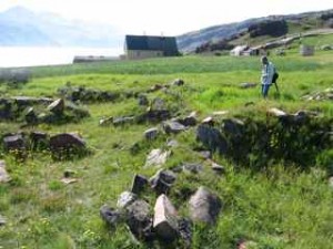
            Qassiarsuk is a splash of primary colors against a background of green.  The brightly painted buildings – a store, a hostel, a church, a school, and farmhouses – are spread along a stretch of one of the longest and busiest roads in southern Greenland.  Norse (and Inuit) ruins dot the hillsides and the coast, rocky foundations of stables, fences, and longhouses all under the watchful eye of Leif Eiriksson, whose statue is set high on a rock above the settlement.

            From our experience with Viking architecture in Iceland, we can tell that most of the visible ruins appear to be medieval, that is, they date to the last century or two of the Norse settlement.  For example, one dwelling has a plan with a central hallway, characteristic of houses built after about 1300 AD.  Earlier structures, which may have been entirely built of turf (without the rocky foundations), are generally visible only as slight hummocks in the terrain or else (presumably) remain buried beneath centuries of accumulated soil.  Our survey of Qassiarsuk strengthened our suspicions that there are many unknown Viking age structures in Greenland, and with any luck the geophysical equipment we brought with us will help us find a few of them!

            A day in Qassiarsuk would not be complete without a visit to the reconstructed turf longhouse and church that sit on a promontory above the iceberg-strewn fjord.  The reconstruction is of course interpreted at Eirik the Red’s house, though it is likely that the nearest ruins do not in fact comprise the original Brattahlid.  We noticed that turf used in the construction is as good as any in Iceland – only to learn later, from the Viking-garbed Icelandic woman who runs the museum, that because proper turf is scarce in Greenland, some of it had actually been imported from Iceland!

            South Greenland has few bogs and is entirely lacking in frost heaves.  Otherwise, however, the landscape is strikingly similar to what we’re familiar with in Northern Iceland – rolling green fields and pastures stretching from the coast through verdant highlands to the sheer rock faces of the mountains.  On a bright and sunny summer’s day – like today – this part of Greenland would have been an inviting image of home to weary travelers from overcrowded Iceland.


Kat


August 3, 2010
by John Steinberg
0 comments

Viking

The name “Viking” evokes so much mythology.  Some of which is true, most of which is not.  In America when you think of Vikings you might think of Leif Erickson.  According to the Icelandic Sagas, Leif was the son of Eric the Red (hence Erickson).  Erik the Red was part outlaw, part explorer.  Eric the Red went from Norway to Iceland (because of some killings) and then in Iceland he was outlawed (again because of some killings).  During his exile from Iceland he found a land west of Iceland, unknown to Europeans.  While most of the land was ice, he did find some palaces that were suitable for the Icelandic farming style that relied on sheep and grass hay fodder.  Erik the Red called this land, Greenland.  About 980 AD Erik and some other folks from Iceland settled Greenland.  These settlements lasted for about 400 years.

While flying over Greenland yesterday, the name seems quite inappropriate (Iceland would have been a better name).  Now deep in Tunugdliaefik (Eric’s fjord) the name seems appropriate on this particularly nice day.

Erik’s son Leif, according to some of those same sagas, sailed to a land he called Vineland, which is in all likelihood North America.  Here in Qassiaesuk (Brattahild) there is large stature of Lief, he overlooks the fjord. We (Brian, Doug, Kat, John & John) decided that a picture was a good idea.

Tomorrow we are off to Igaliko fjord (the fjord just south of Narsarsuaq).  We don’t know how much internet access we wil have.  We will try and post when we have access.


Skip to toolbar