Biodiversity Assessment

Biodiversity Assessment of Savin Hill Cove

 Kyle Schultz, Yuhang Sun, and Ali Yusef were tasked with assessing the current level of biodiversity in the cove today. This included extensive field work in which the team was required to scour the cove in search of any and all forms of living organisms that are present in the cove, in order to obtain a better understanding of the current health state of the ecosystem. Their methods included on-foot observations in order to find total numbers of organisms, and also approximate habitat variation throughout the cove, as well as quadrant testing in both the rocky shore and mudflat areas of the cove. Rocky shore habitats and mudflat habitats tend to be homes to very different types of organisms due to the different physical and environmental characteristics of both. Small area quadrant testing can be used to find approximate population density of a given area.

Along with gathering observations, the team put together an informational packet on the biodiversity of the cove to be distributed to the local communities, so people with little or no biology backgrounds could read and understand the information about the condition of the cove.

The End; Another Beginning

We have arrived at the end of our experience here on Nantucket. Posters and final presentations went well, but overall the program has been a smashing success! We have gained a wealth of knowledge in not only environmental science, but life as well. We thank everyone who had a hand in making our time on island exceptional.

LivingLabs will be on hiatus this summer, but we will be back with a new cohort in the Fall. Look for us then. Or, maybe just watch out 😉


Research Presentation Information

Click on image to make larger

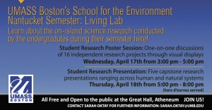
UMass Boston’s School for the Environment
Nantucket Semester: LivingLabs
Learn about the on-island science research conducted by the undergraduates during their semester here!

Student Research Poster Session: One-on-one discussions of 16 independent research projects through visual displays
Wednesday, 17 April from 3:00 – 5:00 PM

Student Research Presentation: Five Capstone research presentations ranging across human and natural systems
Thursday, 18 April from  5:00 – 8:00 PM

All free and open to the public at the Great Hall, Atheneum  – – JOIN US !

Contact Sarah Oktay for further information – sarah.oktay@umb.edu

My life as a scientist

For the past two days I have made an immense amount of progress on my independent study project. Dr. Sarah Oktay was kind enough to take me out to two groundwater wells on Wednesday 3/13 that I had not been to before. I took the normal measurements at each site such as salinity, total dissolved solids, pH, dissolved oxygen, etc. I then took water samples from each site and returned to the UMASS Field Station to do Nitrate and Phosphate tests. Nitrate levels were high for each site, but the water samples showed no change in color. They would usually turn amber if Nitrate was present in a high concentration. So, I decided to let all of my samples sit overnight and I returned today (Thursday 3/14) to retest them. Strangely enough, the Nitrate levels increased dramatically within the samples. Dr. O. explained to me that a possible reason for this hike in Nitrate concentration could be due to microbes in the water. These microbes transform atmospheric nitrogen into ammonia via the process of nitrogen fixation. I still don’t know all of the details but I will keep researching and hope to figure it out! Also, I put all of my data for my independent study into an Excel spreadsheet; Professor Ellen Dounglas would be proud!

Birding at its Best, Trail Posts for Project

Vern Laux, resident bird expert and naturalist took the class out birding yesterday to various sites around Nantucket Island. We encounter a northern mocking bird, which can mimic calls from other birds as well as horns, sirens, or other human made noises. Sifting through a field of Canada geese, we attempted to sneak up on the three Northern Lapwings, some of the rarest birds here in North America, which blew over the Atlantic during the unusual weather events of Hurricane Sandy.

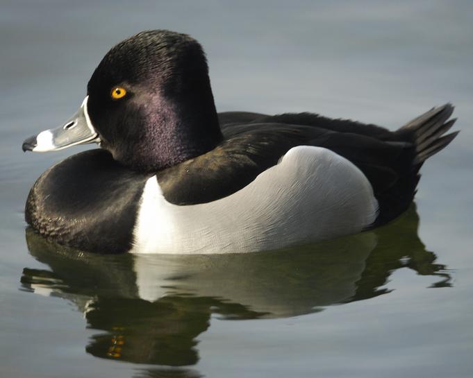
Moving onwards to some of the ponds, we saw American Coots, Ring-Necked Ducks, Wigeons (both American and Eurasian) as well as several types of Gulls and shore birds like the Black Bellied Plover.


Eurasian Wigeon

Ring-Neck Duck


Over head we noted Red Tailed Hawks among the fleet of Crows and other common birds.


Later that day, Vern took me out to the Nantucket Conservation Foundation’s Cranberry Bogs in search of a more uncommon Raptor, although it is found on every continent except Antarctica. There we came across a Peregrine Falcon, full on some recent meal, she lazily sat along the road not far from a flock of small shorebirds called Dunlin. We were able to get nearly 10 meters away and snap some good photos. Through the binoculars I was able to observe the faster animal on earth, full, and lackadaisically perched on a cranberry bog road. Cool Video on Peregrines.

As for my independent project – I have been designing new “self guided nature trail posts” for the 11 posts along the UMB Field Station’s Nature trail. Check here for the Current Posts Virtual Tour. I will be focusing on several different topics, including some birds that may be spotted during the off season months. If other students are interested, it would be great to collaborate on some of these posts in order to bring the research and study on specific topics such as salt marshes, coastal change, or hydrological systems into the field posts.

All for now

Peregrine Falcon, Hunting

Dunlin, a small shore bird

Independent Study

I have made substantial progress with my independent study over the last few weeks. I have spent plenty of time on the computer researching documents and analyzing aerial photographs on Arc GIS software with the help of Eddie Saenz and Steve Nye. Below is my abstract and sample photographs I will be analyzing.

Salt Marshes are unique coastal habitats that provide ecosystem services and hold important roles to the surrounding environment.  The services and roles consist of providing nutrients to the coastal ocean, protection to the mainland, filtering pollutants and decomposition. Medouie Creek salt marsh is located on the northeast portion of Nantucket Island along Polpis Harbor, which is currently being restored. Mosquito ditches and a dike road have changed the hydrology of the area being studied. The main objective of the restoration projected conducted by the Nantucket Conservation Foundation (NCF) was to increase tidal action by installing a low flow box culvert, which increased the salinity and decreased the abundance of the non-native invasive plant Phragmites australis, also known as the Common reed. Improving tidal exchange has been done in hopes of restoring the salt marsh to a suitable state. The trend of this salt marsh shows the changes it has encountered over time from both human and natural activities. An analysis of this specific area using Arc Geographical Information Systems (GIS) will show physical coastal habitat alterations by comparing historic and current aerial photographs of Medouie Creek salt marsh. GIS will also be used to examine the impact of the restoration project and possible management techniques for future success.

Coastal habitat and muddy feet

Biology 306 started this week, which means we’ve been getting our feet wet in the field- literally! We are typically lecturing mid morning and entering marshes either early morning at low tide or early afternoon to obtain water and soil samples. The class has been very hands on and we have beneficially been able to see what we learn within the classroom outside in the field. It has been a lot of work, but a good ride so far. I’ll let you know how Nantucket is next week when I’m a little more sleep deprived from hitting the books 🙂

Rubio and Nicole Folger’s Marsh


Start Your Engines!!!

As we pass the halfway point in this adventure, it is time to crack the whip and make some real headway on my independent study, Primary Productivity by Phytoplankton in Salt Marshes.  The goal of this study will be to assess the levels of primary production, which is the process of converting inorganic molecules, like CO2 and H2O,into vital organic compounds through cellular respiration, and is the base of the estuarine ecosystems food web.  An evaluation of any changes in abundance, species diversity and dominant species will allow for comparison to other variables to see any correlations and possibly point towards a cause for these changes.  Variables for this study will water salinity, temperature, pH, dissolved oxygen (DO) and biological oxygen demand (BOD).  In order to calculate productivity levels I will be extracting chlorophyll a, from the phytoplankton filtered out of the water.  Chlorophyll a is a pigment used in the process of photosynthesis.  Chlorophyll absorbs light of a certain wavelength, and can be measured using a machine called a flourometer.  I will be taking weekly water samples from various site within three different salt marshes around the island.  Samples will be taken back to the lab at the Field Station to be processed for readings with the flourometer.  I had my first interaction with the flourometer this weekend.  Ashley gave me great introduction to how it works and them we took a couple of practice samples from Folger’s Marsh at the Field Station.  On saturday we went through the whole process of filtering the phytoplankton from the water and stored them in the fridge covered in tin foil, to slow photosynthesis and preserving the chlorophyll.  The filters, containing the phytoplankton, were soaked on acetone to separate the chlorophyll.  We also ran a chlorophyll standard curve, a process that involves doing a series of dilutions to a know concentration of chlorophyll, to get a formula that is then used to convert flourometer readings into chlorophyll concentrations.  This afternoon we returned to the Field Station to run our samples through the flourometer.  We were both very excited to see results, because it was not certain that we have enough chlorophyll to read.  Also, it was a sign that we didn’t screw anything up.  Some question did arise during this weekends experiences and I look forward to finding the answers and applying them to my research.  The best part was that I finally realized that I would be able to report some good data by the end my experiments.  I am hopeful that I will also see some changes in levels as the spring rolls in and conditions change.  Soooo, that was a handful, I know but I had to get it there.

Another week has passed and Nantucket island has grown a little more on me.  I was supposed to meet up with a fisherman to go scalloping and do some bycatch assessment, but due to the storm that was delayed until this week which should be very productive being able to go scalloping with a couple different fisherman which should go better.  Its almost like it should’ve happened this way, with being able to get more data than going out once would’ve last week.  I can’t wait to fish and get to know the island from the water.  The fisherman are what make this great island, and I get to hang out with them and learn from them, you knowwwww!!