-

-
Sand Layering by Storm Wash
-
-
Old Beach Berm
-
-
Glacial Deposits Near Pocomo
-

-
Profile of a Beach
A few weeks I was lucky enough to join Dr. Sarah Oktay, Amy Meloski and Llewin Froome to take measurements of a Common Dolphin that had died and washed up onshore near Pocomo Beach. Amy is a volunteer at the New England Aquarium and she gets calls for dead and stranded animals. Last week she recieved a call for another Common Dolphin near Siasconset(pronounced simply Sconset by the locals). Before checking out the new one we went back to Pocomo to see if the first one we saw was still there, in order to help determine if they could be the same animal that just floated with tides and currents. The one at Pocomo was no longer there but due to the location of the new one and the shape of the island we were pretty sure there was no way for them be the same. As we walked down the beach at Pocomo we realized the extent of Nemo’s wrath on Nantucket’s coasts. About ten feet of the bluff along most Polpis Harbor had just dropped off onto the beach, nearly twenty feet below.
The picture titled “Profile of a Beach” is a diagram of the different geological features that make up the beaches on Nantucket. It was drawn by Dr. Robyn Hannigan-(emphasis on the DR.-not artist 😉 HAHA)
The picture on the top left, “Sand Layering by Storm Wash”, is what is found beneath the UMass Boston Field Station. It shows thin layers of sand that were deposited by storms. The bluff near Pocomo also lost the same amount but revealed some more interesting geology.
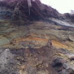
The “Old Beach Berm” picture shows a profile of beach face that has been subsequently covered over through time. The fact that we can see this profile from this view, looking from the current beach, suggests that the beach from that time extended in opposite directions than it does today. The white layer near the top is called Caliche and consists only of sand that has completely leached everything that can possibly be leached out. The dark layer below that is an older B-horizon(basically just a fancy word for distinct layer in soil), and consists of oxygenated minerals, or iron-oxides. The middle of the picture is the profile of the berm itself, and would have a beach ridge and runnel extending in each direction.
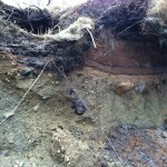
The picture titled “Glacial Deposits Near Pocomo” shows what is know in geology as a conglomerate. A conglomerate is a type of sedimentary rock that consists of many different grain sizes, from sand to boulder, cemented together. This type of formation found here on Nantucket is evidence as to the islands formation, as it can only be deposited by a glacier. Around 12.000-19,000 years ago the Laurentide Ice Sheet stopped here, and began to retreat northward. As it receded, it left behind what is called a terminal moraine, forming Nantucket, Martha’s Vinyard to the west and Cape Cod to the north. The layers above the conglomerate show that sediments have been piling up on the moraine, along with accretion by wave and tidal action, shaping Nantucket into what it is today.
I want to thank Dr. Hannigan for coming out in the rain with Sarah Jacobs, Rubio Rodriguez and myself to explain this to us. You are a great teacher, advisor and friend. Can’t wait for you to make it back to the island. The bacon will be ready when you get here!!!

