
Last fall, we announced that we had discovered the first archaeological features from the 17th-century palisaded town of Plymouth during our 2016 field season on Burial Hill. Now, as we prepare the technical report, we are starting to have a more detailed understanding of the features that we have found and the artifacts in them. This post will discuss those features, and later posts will go into more detail about the different classes of artifacts.

The 2016 features during excavation. Sarah and Anna in the foreground are excavating the calf burial.
In 2015, we had found a very small segment of an early colonial feature: a pit or trench that was cut off on one side by the demolition cut of a later building and ran into the wall of our excavation unit on the other. The section that we had was too small to be able to say much more about it. The disturbed deposits above the feature contained a small number of 17th-century artifacts. One the strength of this discovery, we opened 8 square meters adjacent to this in 2016 which contained a buried ground surface and a complex of 17th-century features, all of which appeared as soil stains. This is what we would expect to see from both Native and early colonial features: areas in the light sandy subsoil that are darker and more organic, representing the locations of pits, trenches, or decomposed posts. All of these features are fairly ephemeral, consisting only of differently colored and textured dirt. Identifying and mapping them relied on careful excavation and documentation. At this level, we switched from our normal quarter-inch mesh screens to eight-inch mesh to find the smallest artifacts. Keeping artifacts together by context (soil layer and feature), drawing and photographing the soil stains, and carefully describing the color and texture of the soil allows us to interpret each feature. This is what we have been doing over the fall and winter, and we can now present a preliminary interpretation, though there is still plenty of work to do!
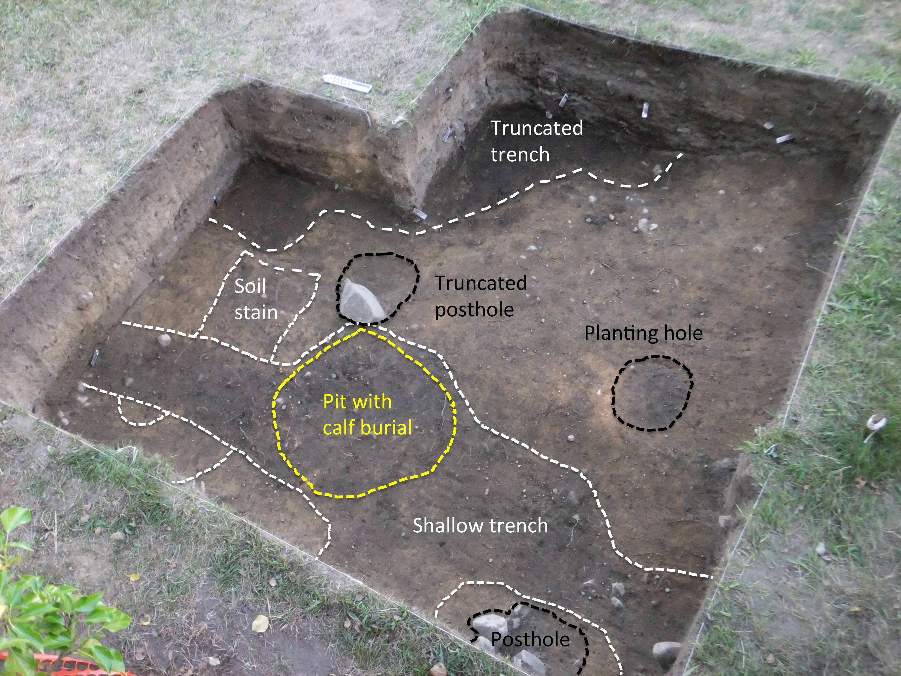
Features discovered in 2016 (north is to the left). The 2015 excavations were east of this area, just beyond the top edge of the photo.
The dark soil along the eastern edge of the excavation area is the continuation of the feature discovered in 2015, a trench with a steep profile, quite broad at the top and deep and narrow at the bottom running NW to SE. It was filled with a very organically enriched soil with a low artifact density: shell and animal bone, fragments of Native ceramic vessels, and a small number of historic ceramics (redware and North Devon), a trade bead, and a small number of nails. In the south central part of the excavation area is a planting hole that contained a large number of fish bones. Running north to south across the 3 meters that we had open was a shallow trench that contained trade beads, straight pins, lithic flakes, and small fragments of Native and European ceramics including some early stoneware and Border ware. In the center of the trench was a much deeper pit used to bury a calf, largely articulated (meaning that the skeleton was still held together by some tissue when it was buried) though missing its head, rear limbs, and feet. There are post holes both east and west of the trench and another faint soil stain at the north edge of the excavation area.
Our preliminary interpretation is that all of these are features outside a house, and that the shallow N-S trench represents the slight depression created by a drip line or walking path just outside a building. Historians of the early town believe that John Alden and Miles Standish owned the houses in this part of the settlement, raising the possibility that we are close to the location of one of their original home sites. Given these features and the Native site excavated in 2015 north of this area, we believe that we have identified the inside and outside of the settlement, and we hope to be able identify the location of the palisade wall in future seasons.
March 23, 2017 at 8:54 AM
It would help frequent visitors to Burial Hill to show a larger picture (or map) of the hill and identifying where the described dig was located.
Steve Fletcher
March 23, 2017 at 2:12 PM
Hi Steve,
This is a great point, but we actually were purposefully not specific about this. Sometimes site location information is not shared, in order to protect sites from metal detecting or illicit digging, which would be a huge concern in and around the historic cemetery.
March 23, 2017 at 3:34 PM
Ok thanks. I actually am connected with Plimoth Plantation and have been on several visits with Dave Landon to burial hill. I just wondered how close to the top of the hill they think the Standish and Alden houses were.